NASA Sees One Area of Strength in Tropical Storm Emang
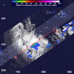
On Jan. 16 at 0702 UTC (2:02 a.m. EST) NASA's TRMM satellite saw mostly moderate rain (in green) in Tropical Storm Emang. There was one small area of heavy rainfall (red) near the center. Credit: SSAI/NASA, Hal Pierce <br>
On Jan. 16 at 0702 UTC (2:02 a.m. EST) NASA's Tropical Rainfall Measuring Mission (TRMM) satellite passed over Emang, and captured rainfall rates. TRMM identified that moderate rain was falling throughout most of the tropical cyclone, and heavy rainfall was occurring near the storm's center. TRMM estimated the heavy rain falling at a rate of 2 inches (50 mm) per hour.
On Jan. 16 at 0900 UTC (4 a.m. EST), Tropical Storm Emang had maximum sustained winds near 35 knots (40 mph/64.8 kph). Emang was located near 14.2 south latitude and 77.7 east longitude, about 580 nautical miles (667.5 miles/1,074 km) southeast of Diego Garcia. Emang is moving slowly to the west at 3 knots (3.4 mph/5.5 kph). Emang is currently not a threat to any land areas.
Emang is expected track west-southwest and may affect La Reunion Island by Jan. 21. However, as it tracks west, after briefly intensifying, wind shear and cooler water temperatures are expected to weaken the storm.
Text Credit: Rob Gutro
NASA's Goddard Space Flight Center, Greenbelt, Md.
Media Contact
All latest news from the category: Earth Sciences
Earth Sciences (also referred to as Geosciences), which deals with basic issues surrounding our planet, plays a vital role in the area of energy and raw materials supply.
Earth Sciences comprises subjects such as geology, geography, geological informatics, paleontology, mineralogy, petrography, crystallography, geophysics, geodesy, glaciology, cartography, photogrammetry, meteorology and seismology, early-warning systems, earthquake research and polar research.


Newest articles

A universal framework for spatial biology
SpatialData is a freely accessible tool to unify and integrate data from different omics technologies accounting for spatial information, which can provide holistic insights into health and disease. Biological processes…

How complex biological processes arise
A $20 million grant from the U.S. National Science Foundation (NSF) will support the establishment and operation of the National Synthesis Center for Emergence in the Molecular and Cellular Sciences (NCEMS) at…

Airborne single-photon lidar system achieves high-resolution 3D imaging
Compact, low-power system opens doors for photon-efficient drone and satellite-based environmental monitoring and mapping. Researchers have developed a compact and lightweight single-photon airborne lidar system that can acquire high-resolution 3D…

