NASA satellite spots newborn Tropical Depression Doksuri in W. Pacific
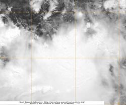
This infrared image from the MODIS instrument onboard NASA's Terra satellite was captured on June 26 at 0228 UTC. The higher thunderstorms around the center of Tropical Depression Doksuri are casting shadows on the lower, less potent storms surrounding them. Credit: Credit: NASA/NRL<br>
The Moderate Imaging Spectroradiometer (MODIS) instrument onboard NASA's Terra satellite as captured an infrared image of the newborn storm on June 26 at 0228 UTC. The image revealed higher thunderstorms around the center of Tropical Depression Doksuri that were casting shadows on the lower, less potent storms surrounding them.
The bands of thunderstorms wrapping into the center of the circulation appear fragmented on infrared imagery. Satellite imagery also shows that the southwestern quadrant has a large area of strong convection (rising air that forms thunderstorms that make up the tropical cyclone) and thunderstorms.
At 1500 UTC (11 a.m .EDT) it was located 545 nautical miles (627 miles/1,009 km) east of Manila, Philippines, near 14.6 North and 130.3 West. It was moving to the west at 10 knots (11.5/18.5 kph)and had maximum sustained winds near 30 knots (34.5 mph/55.5 kph). It is expected to intensify as it is in an area of warm sea surface temperatures, and wind shear is expected to relax. Doksuri is forecast to pass north of Lumon Island, then skirt the coast of China.
Media Contact
More Information:
http://www.nasa.govAll latest news from the category: Earth Sciences
Earth Sciences (also referred to as Geosciences), which deals with basic issues surrounding our planet, plays a vital role in the area of energy and raw materials supply.
Earth Sciences comprises subjects such as geology, geography, geological informatics, paleontology, mineralogy, petrography, crystallography, geophysics, geodesy, glaciology, cartography, photogrammetry, meteorology and seismology, early-warning systems, earthquake research and polar research.


Newest articles

A universal framework for spatial biology
SpatialData is a freely accessible tool to unify and integrate data from different omics technologies accounting for spatial information, which can provide holistic insights into health and disease. Biological processes…

How complex biological processes arise
A $20 million grant from the U.S. National Science Foundation (NSF) will support the establishment and operation of the National Synthesis Center for Emergence in the Molecular and Cellular Sciences (NCEMS) at…

Airborne single-photon lidar system achieves high-resolution 3D imaging
Compact, low-power system opens doors for photon-efficient drone and satellite-based environmental monitoring and mapping. Researchers have developed a compact and lightweight single-photon airborne lidar system that can acquire high-resolution 3D…

