NASA satellite sees Tropical Storm Bingiza hugging the western Madagascar coastline
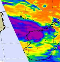
The AIRS instrument that flies aboard NASA\'s Aqua satellite captured an infrared image of Tropical Storm Bingiza today, Feb. 16 at 10:17 UTC (5:17 a.m. EST) that showed some strong convection (purple) over the west-central coast where thunderstorm cloud-tops were high and dropping moderate to heavy rainfall. Credit: NASA JPL, Ed Olsen<br>
The Atmospheric Infrared Sounder (AIRS) instrument that flies aboard NASA's Aqua satellite captured an infrared image of Tropical Storm Bingiza today, Feb. 16 at 10:17 UTC (5:17 a.m. EST).
The image revealed some strong convection over the west-central coast where thunderstorm cloudtops were high and dropping moderate to heavy rainfall. Infrared data can provide temperature information to scientists, which is important as the higher the cloud top, the colder it is, and the stronger the thunderstorm.
Cloud top temperatures as cold as or colder than -52 degrees Celsius (-63 Fahrenheit) were evident in today's AIRS data, suggesting strong thunderstorms still existed, despite Bingiza's weakening over the last 24 hours.
At 0900 UTC (4 a.m. EST) on Feb. 16, Tropical storm Bingiza's maximum sustained winds were near 35 knots (40 mph/64 kmh). It was centered just off-shore from the town of Tambohorano, Madagascar. That's about 200 miles west-northwest of Antananarivo, near 17.4 South and 43.9 East. The eastern half of Tropical Storm Bingiza was over land, while the western half remained over the Mozambique Channel.
At 12 p.m. EST on Feb. 16, rainfall from Bingiza stretched from Mahajanga in the north through Veromanga to Itondy in the south. Tambohorano, a town located along the western coast reported light rainfall at that time.
Bingiza continues to move to the south-southwest near 5 knots and the Joint Typhoon Warning Center forecast suggests that Bingiza will move inland over southern Madagascar in the next couple of days where it will dissipate.
Media Contact
More Information:
http://www.nasa.govAll latest news from the category: Earth Sciences
Earth Sciences (also referred to as Geosciences), which deals with basic issues surrounding our planet, plays a vital role in the area of energy and raw materials supply.
Earth Sciences comprises subjects such as geology, geography, geological informatics, paleontology, mineralogy, petrography, crystallography, geophysics, geodesy, glaciology, cartography, photogrammetry, meteorology and seismology, early-warning systems, earthquake research and polar research.


Newest articles

A universal framework for spatial biology
SpatialData is a freely accessible tool to unify and integrate data from different omics technologies accounting for spatial information, which can provide holistic insights into health and disease. Biological processes…

How complex biological processes arise
A $20 million grant from the U.S. National Science Foundation (NSF) will support the establishment and operation of the National Synthesis Center for Emergence in the Molecular and Cellular Sciences (NCEMS) at…

Airborne single-photon lidar system achieves high-resolution 3D imaging
Compact, low-power system opens doors for photon-efficient drone and satellite-based environmental monitoring and mapping. Researchers have developed a compact and lightweight single-photon airborne lidar system that can acquire high-resolution 3D…

