NASA's Aqua Satellite sees Typhoon Kilo headed west
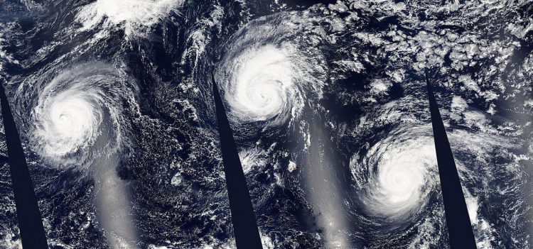
The MODIS instrument aboard NASA's Aqua satellite made several passes over the Pacific Ocean on Sept. 3 and captured Typhoon Kilo (left) and Hurricanes Ignacio (center) and Jimena (right) across the Pacific Ocean. Credits: NASA Goddard MODIS Rapid Response Team
NASA's Aqua satellite passed over Kilo and the Moderate Resolution Imaging Spectroradiometer or MODIS instrument took an image of the storm that showed Kilo maintained an eye and thick bands of thunderstorms wrapping into the low-level center.
Kilo also appeared more symmetric in the MODIS image.
At 11 a.m. EDT (5 a.m. HST/1500 UTC) the center of Typhoon Kilo was located near latitude 24.0 north and longitude 166.0 west. That's 702 nautical miles east-northeast of Wake Island.
The Joint Typhoon Warning Center noted Kilo was moving toward the southwest near 1 knot (1 mph/2 kph). Maximum sustained winds are near 80 knots (92 mph/148 kph).
JTWC expects Kilo to re-intensify over the next several days and peak at 120 knots by September 6 over the open waters of the Northwestern Pacific Ocean.
Media Contact
All latest news from the category: Earth Sciences
Earth Sciences (also referred to as Geosciences), which deals with basic issues surrounding our planet, plays a vital role in the area of energy and raw materials supply.
Earth Sciences comprises subjects such as geology, geography, geological informatics, paleontology, mineralogy, petrography, crystallography, geophysics, geodesy, glaciology, cartography, photogrammetry, meteorology and seismology, early-warning systems, earthquake research and polar research.


Newest articles

A universal framework for spatial biology
SpatialData is a freely accessible tool to unify and integrate data from different omics technologies accounting for spatial information, which can provide holistic insights into health and disease. Biological processes…

How complex biological processes arise
A $20 million grant from the U.S. National Science Foundation (NSF) will support the establishment and operation of the National Synthesis Center for Emergence in the Molecular and Cellular Sciences (NCEMS) at…

Airborne single-photon lidar system achieves high-resolution 3D imaging
Compact, low-power system opens doors for photon-efficient drone and satellite-based environmental monitoring and mapping. Researchers have developed a compact and lightweight single-photon airborne lidar system that can acquire high-resolution 3D…

