NASA Eyes Typhoon Prapiroon's U-Turn
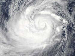
NASA's Aqua satellite passed over Typhoon Prapiroon on Oct. 10 at 0435 UTC (12:35 a.m. EDT) and captured a visible image of the storm while it was in the Philippine Sea. Credit: NASA/Goddard/MODIS Rapid Response Team<br>
NASA's Aqua satellite passed over Typhoon Prapiroon on Oct. 10 at 0435 UTC (12:35 a.m. EDT) and captured a visible image of the storm. The Moderate Resolution Imaging Spectroradiometer (MODIS) instrument was able to get a visible image of the typhoon, because it was 1:35 p.m. local Asia/Tokyo time (and night time on the U.S. East coast at 12:35 a.m. EDT).
The MODIS imagery revealed a well-defined center with tightly curved bands of thunderstorms wrapping into the low-level center of the storm. That's the mark of a strong storm. Although Prapiroon's eye was not apparent in the visible MODIS image, it was in microwave imagery from another satellite instrument.
Typhoon Prapiroon's maximum sustained winds were near 90 knots (103.6 mph/166.7 kph) on Wed. Oct. 10 at 1500 UTC (11 a.m. EDT or 12 a.m. on Thurs. Oct. 11 Asia/Tokyo Time). Prapiroon's center was located about 470 nautical miles (541 miles/870.4 km) south-southeast of Kadena Air Base, Okinawa, Japan, near 19.0 North and 129.6 East. The typhoon had already turned and was moving to the west-northwest at 7 knots (8 mph/12.9 kph).
Prapiroon made the U-turn because of a strong area of elongated high pressure called a ridge that is located south of Japan. The storm is moving around the southwestern edge of the high pressure area. Over the next several days, the storm is expected to intensify because it's in an area of low wind shear and warm waters.
Text credit: Rob Gutro
NASA's Goddard Space Flight Center, Greenbelt, Md.
Media Contact
All latest news from the category: Earth Sciences
Earth Sciences (also referred to as Geosciences), which deals with basic issues surrounding our planet, plays a vital role in the area of energy and raw materials supply.
Earth Sciences comprises subjects such as geology, geography, geological informatics, paleontology, mineralogy, petrography, crystallography, geophysics, geodesy, glaciology, cartography, photogrammetry, meteorology and seismology, early-warning systems, earthquake research and polar research.


Newest articles

Sea slugs inspire highly stretchable biomedical sensor
USC Viterbi School of Engineering researcher Hangbo Zhao presents findings on highly stretchable and customizable microneedles for application in fields including neuroscience, tissue engineering, and wearable bioelectronics. The revolution in…

Twisting and binding matter waves with photons in a cavity
Precisely measuring the energy states of individual atoms has been a historical challenge for physicists due to atomic recoil. When an atom interacts with a photon, the atom “recoils” in…

Nanotubes, nanoparticles, and antibodies detect tiny amounts of fentanyl
New sensor is six orders of magnitude more sensitive than the next best thing. A research team at Pitt led by Alexander Star, a chemistry professor in the Kenneth P. Dietrich…

