NASA Catches Tropical Cyclone Ita Near Papua New Guinea
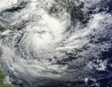
NASA's Terra satellite MODIS instrument captured this image of Tropical Cyclone Ita on April 6. The image shows strong thunderstorms surrounding the tightly-wrapped center of circulation, just southeast of Sudest Island. Image Credit: NASA Goddard MODIS Rapid Response Team
On April 5 at 2100 UTC/5:00 p.m. EDT, Ita formed in the Coral Sea, about 599 nautical miles east-northeast of Cairns, Australia, and was moving to the west-southwestward at 5 knots/5.7 mph/9.2 kph. At that time, maximum sustained winds were near 45 knots/51.7 mph/83 kph.
Satellite data on April 5 showed that strong convection (and developing thunderstorms) were along both the southern and eastern quadrants of the newborn storm.
On April 6, when NASA's Terra satellite passed over Ita the Moderate Resolution Imaging Spectroradiometer (MODIS) instrument captured a visible image of the storm. The image was created by NASA's MODIS Rapid Response Team at the NASA Goddard Space Flight Center in Greenbelt, Md.
The MODIS image showed strong thunderstorms surrounding the tightly-wrapped center of circulation, just southeast of Sudest Island. Bands of thunderstorms were wrapping into the center from the north and east, and from the southwest.
At 1200 UTC/8 a.m. EDT/10 p.m. local time (Brisbane/Australia) on April 7, Tropical Cyclone Ita was located over the northern Coral Sea near latitude 12.1 south and longitude 153.4 east, about 532 nautical miles/612.2 miles/985.3 km northeast of Cairns, Queensland. Maximum sustained winds were near 45 knots/51.7 mph/83.3 kph.
The Joint Typhoon Warning Center (JTWC) expects Ita to move to the west then southwest over the next several days. JTWC forecasters expect Ita to make landfall in the northeastern Cape York Peninsula of Queensland, Australia around April 11. Currently there are no watches posted yet, but the Australian Bureau of Meteorology noted that Ita could begin affecting the Queensland coast on Wednesday, April 9.
Text credit: Rob Gutro
NASA's Goddard Space Flight Center
Media Contact
All latest news from the category: Earth Sciences
Earth Sciences (also referred to as Geosciences), which deals with basic issues surrounding our planet, plays a vital role in the area of energy and raw materials supply.
Earth Sciences comprises subjects such as geology, geography, geological informatics, paleontology, mineralogy, petrography, crystallography, geophysics, geodesy, glaciology, cartography, photogrammetry, meteorology and seismology, early-warning systems, earthquake research and polar research.


Newest articles

Sea slugs inspire highly stretchable biomedical sensor
USC Viterbi School of Engineering researcher Hangbo Zhao presents findings on highly stretchable and customizable microneedles for application in fields including neuroscience, tissue engineering, and wearable bioelectronics. The revolution in…

Twisting and binding matter waves with photons in a cavity
Precisely measuring the energy states of individual atoms has been a historical challenge for physicists due to atomic recoil. When an atom interacts with a photon, the atom “recoils” in…

Nanotubes, nanoparticles, and antibodies detect tiny amounts of fentanyl
New sensor is six orders of magnitude more sensitive than the next best thing. A research team at Pitt led by Alexander Star, a chemistry professor in the Kenneth P. Dietrich…

