NASA captures birth of Tropical Cyclone Olwyn headed for northwestern Australia
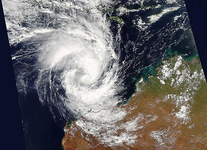
Tropical Cyclone Olwyn is nearing northwestern Australia in this image from NASA's Aqua satellite on March 11. Image Credit: NASA Goddard MODIS Rapid Response
Data from the Moderate Resolution Imaging Spectroradiometer or MODIS instrument that flies aboard NASA's Aqua satellite is gathered and processed daily into images at NASA's Goddard Space Flight Center in Greenbelt, Maryland.
On March 12 at 05:50 UTC (1:50 a.m. EDT) imagery generated from the Moderate Resolution Imaging Spectroradiometer or MODIS instrument that flies aboard NASA's Aqua satellite showed Tropical Cyclone Olwyn in the Southern Indian Ocean approaching the northern coast of Western Australia.
Olwyn has generated warnings in northern Western Australia. A tropical cyclone warning is in effect for coastal areas of Western Australia from Port Hedland to Ningaloo, including Karratha, Barrow Island, Onslow, Pannawonica, Nanutarra and Exmouth (not including Port Hedland).
In addition, a tropical cyclone watch is in effect from Ningaloo to Kalbarri, and adjacent inland areas of the west Pilbara and west Gascoyne, including Gascoyne Junction and Murchison Roadhouse.
In addition to the warnings and watches, the Australian Bureau of Meteorology has posted a blue alert for residents in or near Whim Creek to Coral Bay extending inland to Pannawonica.
This includes people in the locations of Whim Creek, Point Samson, Wickham, Roebourne, Karratha, Dampier, Onslow, Pannawonica and Exmouth.
Olwyn has formed north of Exmouth and is forecast to move south-southwest while intensifying. At 1500 UTC (11 a.m. EST), Olwyn was centered near 17.3 south latitude and 116.0 east longitude, about 233 nautical miles (268 miles/431.5 km) northwest of Port Hedland, Australia.
Olwyn is moving to the south-southwest at 12 knots (13.8 mph/22.2 kph) and has maximum sustained winds near 55 knots (63.2 mph/102 kph).
Olwyn is forecast to make landfall near Cape Cuvier in the early hours of Friday (local time) and dissipate in the interior of Western Australia.
Media Contact
All latest news from the category: Earth Sciences
Earth Sciences (also referred to as Geosciences), which deals with basic issues surrounding our planet, plays a vital role in the area of energy and raw materials supply.
Earth Sciences comprises subjects such as geology, geography, geological informatics, paleontology, mineralogy, petrography, crystallography, geophysics, geodesy, glaciology, cartography, photogrammetry, meteorology and seismology, early-warning systems, earthquake research and polar research.


Newest articles

Sea slugs inspire highly stretchable biomedical sensor
USC Viterbi School of Engineering researcher Hangbo Zhao presents findings on highly stretchable and customizable microneedles for application in fields including neuroscience, tissue engineering, and wearable bioelectronics. The revolution in…

Twisting and binding matter waves with photons in a cavity
Precisely measuring the energy states of individual atoms has been a historical challenge for physicists due to atomic recoil. When an atom interacts with a photon, the atom “recoils” in…

Nanotubes, nanoparticles, and antibodies detect tiny amounts of fentanyl
New sensor is six orders of magnitude more sensitive than the next best thing. A research team at Pitt led by Alexander Star, a chemistry professor in the Kenneth P. Dietrich…

