NASA's Terra satellite spots Hurricane Humberto's cloud-filled eye
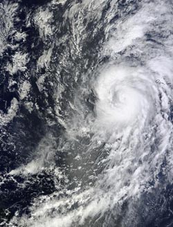
The MODIS instrument aboard NASA's Terra satellite captured this image of Hurricane Humberto on Sept. 11 at 9 a.m. EDT in the eastern Atlantic, west of the Cape Verde Islands.<br><br>Credit: NASA Goddard MODIS Rapid Response Team<br>
On Thursday, Sept. 12 at 11 a.m. EDT/1500 UTC, Hurricane Humberto has maximum near 85 mph/140 kph, and the National Hurricane Center (NHC) expects gradual weakening later in the day.
The center of Hurricane Humberto was located near latitude 21.8 north and longitude 29.0 west, about 515 miles/830 km northwest of the Cape Verde Islands. Humberto is moving toward the north near 15 mph/24 kph and NHC expects a gradual turn toward the northwest and west-northwest. The estimated minimum central pressure is 982 millibars.
Hurricane force winds extend outward up to 35 miles/55 km from the center and tropical storm force winds extend outward up to 175 miles/280 km.
Satellite data indicates that there is some wind shear blowing from the south-southwest over Hurricane Humberto. However, Humberto appears fairly well organized in visible and infrared imagery.
The Moderate Resolution Imaging Spectroradiometer or MODIS instrument aboard NASA's Terra satellite captured a visible image of Hurricane Humberto on Sept. 11 at 9 a.m. EDT that showed a very small eye and bands of thunderstorms feeding into the storm.
The NHC expects the wind shear to increase from the west-southwest and Humberto will track into cooler waters. Both of those factors are expected to weaken Humberto below hurricane strength in the next couple of days.
Media Contact
More Information:
http://www.nasa.govAll latest news from the category: Earth Sciences
Earth Sciences (also referred to as Geosciences), which deals with basic issues surrounding our planet, plays a vital role in the area of energy and raw materials supply.
Earth Sciences comprises subjects such as geology, geography, geological informatics, paleontology, mineralogy, petrography, crystallography, geophysics, geodesy, glaciology, cartography, photogrammetry, meteorology and seismology, early-warning systems, earthquake research and polar research.


Newest articles

A universal framework for spatial biology
SpatialData is a freely accessible tool to unify and integrate data from different omics technologies accounting for spatial information, which can provide holistic insights into health and disease. Biological processes…

How complex biological processes arise
A $20 million grant from the U.S. National Science Foundation (NSF) will support the establishment and operation of the National Synthesis Center for Emergence in the Molecular and Cellular Sciences (NCEMS) at…

Airborne single-photon lidar system achieves high-resolution 3D imaging
Compact, low-power system opens doors for photon-efficient drone and satellite-based environmental monitoring and mapping. Researchers have developed a compact and lightweight single-photon airborne lidar system that can acquire high-resolution 3D…

