NASA's Aqua Satellite sees Khanun's remnants dissipating over China
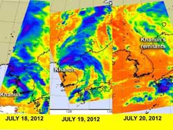
... of the time series of infrared imagery from the AIRS instrument on NASA's Aqua satellite showing the progress of Tropical Depression Khanun before, during and after landfall on July 18, 19 and 20. Purple areas indicate coldest cloud top temperatures, strongest storms and heaviest rainfall.<br><br>Credit: Credit: NASA JPL, Ed Olsen<br>
NASA's Aqua satellite passed over Khanun on July 18, 19 and 20 and tracked the northeastern progression of the tropical cyclone after it made landfall. On Wednesday, July 18 at 1659 UTC (12:59 p.m. EDT/U.S.), Tropical Depression Khanun's center was still in the Yellow Sea (west of South Korea).
At that time, the Atmospheric Infrared Sounder (AIRS) instrument onboard NASA's Aqua satellite saw a band of thunderstorms with cloud top temperatures colder than 220 kelvin (-63.6 F/-53.1C) over western South Korea, bringing heavy rainfall. A larger area of thunderstorms with cloud top temperatures as cold as -63F/-53C were over western North Korea at that time, dropping moderate rainfall.
Tropical Depression Khanun came ashore in western South Korea, bringing heavy rainfall with it on Thursday, July 19 as it moved in a north-northeasterly direction toward North Korea and northeastern China. On July 19 at 0405 UTC (12:05 a.m. EDT/U.S.), the heaviest rainfall and strongest thunderstorms appeared to be over the Kangnam Mountains in northern North Korea that also border eastern China. The Kangnam Mountains lie west of the Rangrim Mountains.
Although the center of Khanun's remnants moved into the Sea of Japan, it was bringing some scattered showers and thunderstorms to a few areas in northeastern China on July 20. NASA's Aqua satellite passed over the region on July 20 at 0447 UTC (12:47 a.m. EDT) and showed some scattered showers moving east into Khabarovsk Krai, Russia, a federal subject of Russia. Khunan's remnants are expected to dissipate today.
Media Contact
More Information:
http://www.nasa.govAll latest news from the category: Earth Sciences
Earth Sciences (also referred to as Geosciences), which deals with basic issues surrounding our planet, plays a vital role in the area of energy and raw materials supply.
Earth Sciences comprises subjects such as geology, geography, geological informatics, paleontology, mineralogy, petrography, crystallography, geophysics, geodesy, glaciology, cartography, photogrammetry, meteorology and seismology, early-warning systems, earthquake research and polar research.


Newest articles

Webb captures top of iconic horsehead nebula in unprecedented detail
NASA’s James Webb Space Telescope has captured the sharpest infrared images to date of a zoomed-in portion of one of the most distinctive objects in our skies, the Horsehead Nebula….

Cost-effective, high-capacity, and cyclable lithium-ion battery cathodes
Charge-recharge cycling of lithium-superrich iron oxide, a cost-effective and high-capacity cathode for new-generation lithium-ion batteries, can be greatly improved by doping with readily available mineral elements. The energy capacity and…

Novel genetic plant regeneration approach
…without the application of phytohormones. Researchers develop a novel plant regeneration approach by modulating the expression of genes that control plant cell differentiation. For ages now, plants have been the…

