NASA Spots Active Southern Indian Ocean's Tropical Storm 18S
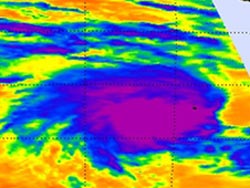
On Feb. 24 at 2:29 a.m. EST the AIRS instrument aboard NASA's Aqua satellite captured infrared data on TS18S. The coldest temperatures (purple) and highest cloud tops (and strongest thunderstorms) appeared in a large area around TD18S's center. Credit: NASA/JPL, Ed Olsen<br>
Cyclone Rusty is nearing a landfall in northwestern West Australia, while Tropical Storm 18S is headed in a similar direction.
Tropical Storm 18S (TS18S) was born on Feb. 24 and achieved tropical storm strengthe with maximum sustained winds near 35 knots (40 mph). It formed about 45 nautical miles southeast of the Cocos Islands, Australia near 12.7 south latitude and 97.3 east longitude.
Wind shear on Feb. 24 was affecting the storm, and pushing the strongest thunderstorms west of the center. NASA's TRMM satellite captured data on rainfall and noted the strongest rainfall was occurring west of the center at a rate of more than 1.4 inches per hour.
On Feb. 24 at 0729 UTC (2:29 a.m. EST), the Atmospheric Infrared Sounder (AIRS) instrument aboard NASA's Aqua satellite captured infrared data on TS18S. The data was created into a false-colored image at NASA's Jet Propulsion Laboratory in Pasadena, Calif. False coloration enables meteorologists to see distinction in temperatures, and the coldest temperatures and highest cloud tops (and strongest thunderstorms) appeared in a large area around TD18S's center. Cloud top temperatures around the center exceeded the -63 Fahrenheit (-52 Celsius) threshold, indicating that those areas were likely dropping heavy rainfall.
Satellite data has shown that wind shear is still affecting the tropical storm, and pushing the main convection to the west. That wind shear is expected to persist over the next couple of days before easing up.
On Feb. 25 at 1500 UTC (10 a.m. EST) Tropical Storm 18S was located about 980 nautical miles (1,128 miles/1,815 km) west-northwest of Learmonth, Australia, near 14.7 south and 99.0 east. TS18S had maximum sustained winds near 35 knots (40.2 mph/64.8 kph) and was moving to the southeast near 6 knots (6.9 mph/11.1 kph).
Forecasters at the Joint Typhoon Warning Center expect TS18S to take an easterly track, toward Port Hedland and Learmonth, Western Australia after the second of March. If that occurs, the residents of northwestern Australia will be recovering from Cyclone Rusty when Tropical Storm 18S approaches.
Text Credit: Rob Gutro
NASA's Goddard Space Flight Center, Greenbelt, Md.
Media Contact
All latest news from the category: Earth Sciences
Earth Sciences (also referred to as Geosciences), which deals with basic issues surrounding our planet, plays a vital role in the area of energy and raw materials supply.
Earth Sciences comprises subjects such as geology, geography, geological informatics, paleontology, mineralogy, petrography, crystallography, geophysics, geodesy, glaciology, cartography, photogrammetry, meteorology and seismology, early-warning systems, earthquake research and polar research.


Newest articles

High-energy-density aqueous battery based on halogen multi-electron transfer
Traditional non-aqueous lithium-ion batteries have a high energy density, but their safety is compromised due to the flammable organic electrolytes they utilize. Aqueous batteries use water as the solvent for…

First-ever combined heart pump and pig kidney transplant
…gives new hope to patient with terminal illness. Surgeons at NYU Langone Health performed the first-ever combined mechanical heart pump and gene-edited pig kidney transplant surgery in a 54-year-old woman…

Biophysics: Testing how well biomarkers work
LMU researchers have developed a method to determine how reliably target proteins can be labeled using super-resolution fluorescence microscopy. Modern microscopy techniques make it possible to examine the inner workings…

