Extensional tectonics in Tempe Terra
Extensional tectonics in Tempe Terra
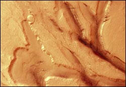
These images, taken by the High Resolution Stereo Camera (HRSC) on board ESA’s Mars Express spacecraft, show the tectonic ’grabens’ in Tempe Terra, a geologically complex region that is part of the old Martian highlands.
The HRSC obtained these images during orbit 1180 on 19 December 2004 with a ground resolution of approximately 16.5 metres per pixel. The data were acquired in the region of Northern Olympus Mons, at approximately 48.5° North and 288.4° East.
The Tempe Terra region of Mars displays a complex geologic history; the images were taken just west of the Barabashov crater and cover the transition zone between the old Martian highlands to the south and the geologically younger northern lowlands.
The context map is centred on the region of Mareotis Fossae showing numerous parallel grabens, or depressed blocks of land bordered by parallel faults, running in a Northeast-Southwest orientation. These appear in more detail in the south (left) of the camera images.
Tectonic processes (extensional stresses, in this case) have led to the development of these grabens. After the tectonic activity, other processes reshaped the landscape. In the scene, the results of weathering and mass transport can be seen. Due to erosion, the surface has been smoothed, giving formerly sharp edges a rounded appearance. Such terrain is called “fretted terrain” and is characteristic for the transition of highland to lowland.
The valleys and grabens are 5 to 10 kilometres wide and up to 1500 metres deep. Along the graben flanks, the layering of the bedrock is exposed. The lineations on the valley floors are attributed to a slow viscous movement of material, presumably in connection with ice. These lineations and indications of possible ice underneath the surface lead scientists to assume that the structures are rock glaciers or similar phenomena known from alpine regions on Earth.
The stereo and colour capabilities, and the high-resolution coverage of extended areas, provided by the HRSC camera allow for improved study of the complex geologic evolution of the Red Planet. The Mars Express HRSC camera gives scientists the opportunity to better understand the tectonics of Mars, including processes active in the more recent geologic history.
The colour scene was derived from the three HRSC-colour channels and the nadir channel. The 3D anaglyph image was calculated from the nadir and one stereo channel. Image resolution has been decreased for use on the internet.
Media Contact
More Information:
http://www.esa.int/esaSC/SEM8LI8ATME_index_0.htmlAll latest news from the category: Physics and Astronomy
This area deals with the fundamental laws and building blocks of nature and how they interact, the properties and the behavior of matter, and research into space and time and their structures.
innovations-report provides in-depth reports and articles on subjects such as astrophysics, laser technologies, nuclear, quantum, particle and solid-state physics, nanotechnologies, planetary research and findings (Mars, Venus) and developments related to the Hubble Telescope.


Newest articles

Webb captures top of iconic horsehead nebula in unprecedented detail
NASA’s James Webb Space Telescope has captured the sharpest infrared images to date of a zoomed-in portion of one of the most distinctive objects in our skies, the Horsehead Nebula….

Cost-effective, high-capacity, and cyclable lithium-ion battery cathodes
Charge-recharge cycling of lithium-superrich iron oxide, a cost-effective and high-capacity cathode for new-generation lithium-ion batteries, can be greatly improved by doping with readily available mineral elements. The energy capacity and…

Novel genetic plant regeneration approach
…without the application of phytohormones. Researchers develop a novel plant regeneration approach by modulating the expression of genes that control plant cell differentiation. For ages now, plants have been the…

