Oozing across Titan?
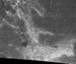
Radar image of Titan’s surface
This synthetic aperture radar image of the surface of Saturn’s moon Titan was taken on 26 October 2004, when the NASA/ESA/ASI Cassini-Huygens spacecraft flew about 2500 kilometres above the surface and acquired radar data for the first time.
The radar illumination was from the south: dark regions may represent areas that are smooth, made of radar-absorbing materials, or are sloped away from the direction of illumination.
A striking bright feature stretches from upper left to lower right across this image, with connected ’arms’ to the east. The fact that the lower (southern) edges of the features are brighter is consistent with the structure being raised above the relatively featureless darker background.
Comparisons with other features and data from other instruments will help to determine whether this is a ’cryovolcanic’ flow, where water-rich liquid has welled up from Titan’s warm interior.
The image covers an area about 150 kilometres square, and is centred at about 45 degrees north, 30 degrees west in the northern hemisphere of Titan, over a region that has not yet been imaged optically. The smallest details seen on the image are around one kilometre across.
The Cassini-Huygens mission is a co-operative project of NASA, ESA and ASI, the Italian space agency.
Media Contact
More Information:
http://www.esa.intAll latest news from the category: Physics and Astronomy
This area deals with the fundamental laws and building blocks of nature and how they interact, the properties and the behavior of matter, and research into space and time and their structures.
innovations-report provides in-depth reports and articles on subjects such as astrophysics, laser technologies, nuclear, quantum, particle and solid-state physics, nanotechnologies, planetary research and findings (Mars, Venus) and developments related to the Hubble Telescope.


Newest articles

A universal framework for spatial biology
SpatialData is a freely accessible tool to unify and integrate data from different omics technologies accounting for spatial information, which can provide holistic insights into health and disease. Biological processes…

How complex biological processes arise
A $20 million grant from the U.S. National Science Foundation (NSF) will support the establishment and operation of the National Synthesis Center for Emergence in the Molecular and Cellular Sciences (NCEMS) at…

Airborne single-photon lidar system achieves high-resolution 3D imaging
Compact, low-power system opens doors for photon-efficient drone and satellite-based environmental monitoring and mapping. Researchers have developed a compact and lightweight single-photon airborne lidar system that can acquire high-resolution 3D…

