Tropical Storm Tomas calls for alerts in south Pacific
Forecasters at the Fiji Meteorological Service (FMS) have posted a tropical cyclone alert for the South Pacific islands of Wallis and Futuna on March 11 at 05:53 UTC (12:53 a.m. ET). The FMS has also designated the storm as “Tropical Depression 14F.”
The Territory of the Wallis and Futuna Islands is a Polynesian French island territory in the South Pacific between Fiji and Samoa. It consists of three main volcanic tropical islands and several islets.
At 1500 UTC (10 a.m. ET) Tropical Storm Tomas was located near 11.0 South latitude and 175.5 West longitude about 340 miles northwest of Pago Pago. It was moving west near 8 mph (7 knots). Tomas' maximum sustained winds were estimated near 39 mph (35 knots) and it was generating waves up to 11 feet high.
Tomas appears to continue strengthening, as bands of thunderstorms continue to wrap around the storm's low level center. NASA's Aqua infrared satellite imagery from the Atmospheric Infrared Sounder (AIRS) instrument confirm some deep convection (rapidly rising air that creates the thunderstorms that power tropical cyclones). The infrared image of Tomas captured on March 11 at 0105 UTC (Mar. 10 at 8:05 p.m. ET) showed some high, cold thunderstorms around the center of this large storm.
As the storm continues to intensify and move southwest, residents of the Wallis and Futuna Islands should pay close attention to their local forecasts. It is expected to become a cyclone in the next day or two.
For updates from the Fiji Meteorological Service: http://www.met.gov.fj/
For updates from the Tonga Meteorological Service: http://www.met.gov.to
Media Contact
More Information:
http://www.nasa.govAll latest news from the category: Earth Sciences
Earth Sciences (also referred to as Geosciences), which deals with basic issues surrounding our planet, plays a vital role in the area of energy and raw materials supply.
Earth Sciences comprises subjects such as geology, geography, geological informatics, paleontology, mineralogy, petrography, crystallography, geophysics, geodesy, glaciology, cartography, photogrammetry, meteorology and seismology, early-warning systems, earthquake research and polar research.


Newest articles
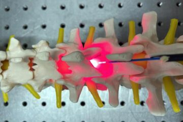
Red light therapy for repairing spinal cord injury passes milestone
Patients with spinal cord injury (SCI) could benefit from a future treatment to repair nerve connections using red and near-infrared light. The method, invented by scientists at the University of…
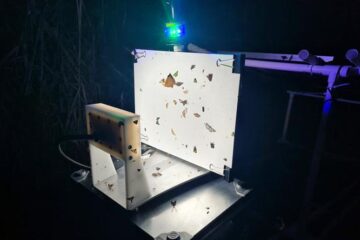
Insect research is revolutionized by technology
New technologies can revolutionise insect research and environmental monitoring. By using DNA, images, sounds and flight patterns analysed by AI, it’s possible to gain new insights into the world of…
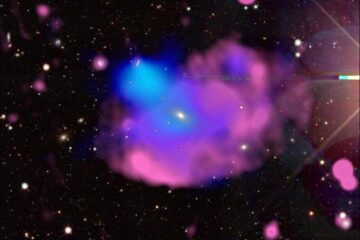
X-ray satellite XMM-newton sees ‘space clover’ in a new light
Astronomers have discovered enormous circular radio features of unknown origin around some galaxies. Now, new observations of one dubbed the Cloverleaf suggest it was created by clashing groups of galaxies….

