Tropical Storm Pewa Passing Wake Island
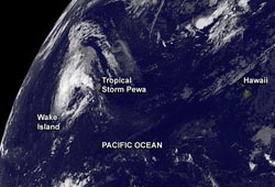
NOAA's GOES-West satellite captured an image of Pewa on Aug. 21 at 1500 UTC/11 a.m. EDT as it continues to move farther west in the Northwestern Pacific Ocean. Image Credit: NASA GOES Project<br>
Tropical Storm Pewa continues trekking through the open waters of the Northwestern Pacific Ocean today, and was captured on NASA satellite imagery.
On Aug. 21 at 1500 UTC, Tropical Storm Pewa had maximum sustained winds near 35 knots/40.2 mph/64.8 kph. Pewa is a small storm, and tropical-storm-force winds extend from the center up to 65 miles. It was centered near 20.9 north latitude and 170.4 east longitude, about 242 nautical miles/278.5 miles/448.2 km east-northeast of Wake Island.
Wake Island is a coral atoll. Its coastline stretches only 12 miles/19 km and it is located just north of the Marshall Islands. Pewa continues moving past Wake Island in a north-northwesterly direction at 12 knots/13.8 mph/22.2 kph.
NOAA's GOES-West satellite captured an image of Pewa on Aug. 21 at 1500 UTC/11 a.m. EDT. GOES-West imagery is created at the NASA GOES Project at NASA Goddard Space Flight Center in Greenbelt, Md. The GOES-West satellite data showed Pewa still has bands of thunderstorms around the center and northern quadrant of the circulation.
Pewa is expected to intensify again while moving northwest. The Joint Typhoon Warning Center forecast indicates that it is expected to become a typhoon over the next five days.
Text credit: Rob Gutro
NASA's Goddard Space Flight Center
Media Contact
All latest news from the category: Earth Sciences
Earth Sciences (also referred to as Geosciences), which deals with basic issues surrounding our planet, plays a vital role in the area of energy and raw materials supply.
Earth Sciences comprises subjects such as geology, geography, geological informatics, paleontology, mineralogy, petrography, crystallography, geophysics, geodesy, glaciology, cartography, photogrammetry, meteorology and seismology, early-warning systems, earthquake research and polar research.


Newest articles

A universal framework for spatial biology
SpatialData is a freely accessible tool to unify and integrate data from different omics technologies accounting for spatial information, which can provide holistic insights into health and disease. Biological processes…

How complex biological processes arise
A $20 million grant from the U.S. National Science Foundation (NSF) will support the establishment and operation of the National Synthesis Center for Emergence in the Molecular and Cellular Sciences (NCEMS) at…

Airborne single-photon lidar system achieves high-resolution 3D imaging
Compact, low-power system opens doors for photon-efficient drone and satellite-based environmental monitoring and mapping. Researchers have developed a compact and lightweight single-photon airborne lidar system that can acquire high-resolution 3D…

