Tropical Depression 21W Forms, Philippines Under Warnings
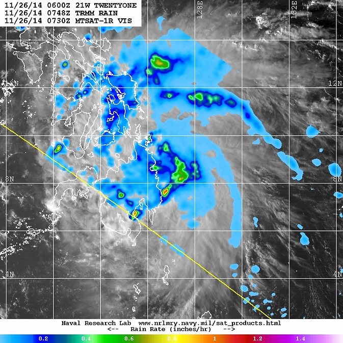
On Nov. 26, the TRMM satellite revealed areas of heavy rainfall in fragmented bands east of the center of circulation, where rain was falling at more than 1 inch (25 mm) per hour (red). Japan's MTSAT-1 satellite provided cloud data. Image Credit: NASA/NRL
TRMM revealed areas of heavy rainfall in fragmented bands east of the center of circulation, where rain was falling at more than 1 inch (25 mm) per hour.
TRMM rainfall data was overlaid on infrared data from the Japan Meteorological Agency's MTSAT-1 satellite that showed Tropical Depression 21W's (TD21W) clouds extended from western Mindanao, east into the Philippine Sea.
On Nov. 26, there were a number of warnings in effect for the Philippines. Public storm warning signal #1 was in effect for the province of Luzon that includes: Palawan and the Calamian Group of Islands. In Visayas: Southern Leyte, Bohol, Southern Cebu Including Cebu City, Negros Oriental, Southern Negros Occidental and Siquijor. In the province of Mindanao:
Surigao del Norte including Siargao Island, Surigao del Sur, Agusan del Norte & Sur, Dinagat Province, Camiguin, Misamis Oriental & Occidental, Bukidnon and Zamboanga del Norte.
At 1500 UTC (10 a.m. EST), TD21W was centered near 8.7 north longitude and 125.4 east latitude. That's about 468 nautical miles (538.6 miles/866.7 kph) southeast of Manila, Philippines. Maximum sustained winds were near 30 knots (34.5 mph/55.5 kph). TD21W is moving to the west at 9 knots (10.3 mph/16.6 kph).
TD 21W is forecast to continue tracking westward along the southern edge of a sub-tropical ridge of high pressure which is located to the north of the depression and oriented east-west. The Joint Typhoon Warning Center forecasts TD21W to move over northern Mindanao late on Nov. 26 and weaken. By Nov. 27, TD21W is expected to emerge into the Sulu Sea where it is expected to strengthen.
Rob Gutro
NASA's Goddard Space Flight Center
Media Contact
All latest news from the category: Earth Sciences
Earth Sciences (also referred to as Geosciences), which deals with basic issues surrounding our planet, plays a vital role in the area of energy and raw materials supply.
Earth Sciences comprises subjects such as geology, geography, geological informatics, paleontology, mineralogy, petrography, crystallography, geophysics, geodesy, glaciology, cartography, photogrammetry, meteorology and seismology, early-warning systems, earthquake research and polar research.


Newest articles

A universal framework for spatial biology
SpatialData is a freely accessible tool to unify and integrate data from different omics technologies accounting for spatial information, which can provide holistic insights into health and disease. Biological processes…

How complex biological processes arise
A $20 million grant from the U.S. National Science Foundation (NSF) will support the establishment and operation of the National Synthesis Center for Emergence in the Molecular and Cellular Sciences (NCEMS) at…

Airborne single-photon lidar system achieves high-resolution 3D imaging
Compact, low-power system opens doors for photon-efficient drone and satellite-based environmental monitoring and mapping. Researchers have developed a compact and lightweight single-photon airborne lidar system that can acquire high-resolution 3D…

