TRMM maps flooding along US East Coast from massive storm
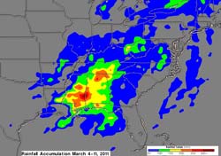
Although the heaviest rainfall last week was in the southern United States, flooding was reported in states from Louisiana to northern New York. A rainfall analysis was created made by merging precipitation data from multiple satellites.
This Multisatellite Precipitation Analysis (TMPA) analysis used data that were calibrated with TRMM precipitation data. These data are calculated and stored at NASA Goddard and are available within a few hours after being received by satellites.
The analysis indicated that the greatest total rainfall for the past week was over 300 mm (~11 inches) and was located over Alabama and Mississippi. Some of the extremely heavy rainfall in this area was associated with tornado spawning thunderstorms (see: http://trmm.gsfc.nasa.gov/publications_dir/tornadoes_7-10may11.html).
Much of the eastern United States was affected by rainfall totals of over 50 mm (~2 inches). As the weather system moved east, some of the most impressive rainfall totals in the Mid-Atlantic fell between Baltimore, Md. and Charlottesville, Va. On Thursday, March 10, Baltimore set a new daily rainfall record measuring 2.61 inches according to the National Weather Service. Charlottesville received 2.33 inches of rainfall from the system. To the west, Martinsburg, West Virginia also reported a daily record rainfall total of 1.26 inches. Many areas had flooding with totals that were less than the extreme amounts shown on the rainfall analysis.
Hal Pierce/Rob Gutro
NASA's Goddard Space Flight Center
Media Contact
All latest news from the category: Earth Sciences
Earth Sciences (also referred to as Geosciences), which deals with basic issues surrounding our planet, plays a vital role in the area of energy and raw materials supply.
Earth Sciences comprises subjects such as geology, geography, geological informatics, paleontology, mineralogy, petrography, crystallography, geophysics, geodesy, glaciology, cartography, photogrammetry, meteorology and seismology, early-warning systems, earthquake research and polar research.


Newest articles

A universal framework for spatial biology
SpatialData is a freely accessible tool to unify and integrate data from different omics technologies accounting for spatial information, which can provide holistic insights into health and disease. Biological processes…

How complex biological processes arise
A $20 million grant from the U.S. National Science Foundation (NSF) will support the establishment and operation of the National Synthesis Center for Emergence in the Molecular and Cellular Sciences (NCEMS) at…

Airborne single-photon lidar system achieves high-resolution 3D imaging
Compact, low-power system opens doors for photon-efficient drone and satellite-based environmental monitoring and mapping. Researchers have developed a compact and lightweight single-photon airborne lidar system that can acquire high-resolution 3D…

