Satellite views Chantal's remnants over Bahamas
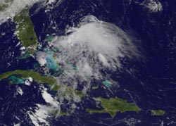
This visible image from NOAA's GOES-13 satellite shows the remnant clouds and showers from Chantal over the Bahamas and the adjacent Atlantic waters at 9:45 a.m. EDT on July 12, 2013.<br><br>Credit: NASA GOES Project<br>
A visible image from NOAA's GOES-13 satellite at 9:45 a.m. EDT on July 12, 2013 showed Chantal's remnant clouds and showers moving north in the Atlantic.
The image of Chantal's remnants resembled the sideways view of a jellyfish. The GOES image was created by NASA's GOES Project at the NASA Goddard Space Flight Center, Greenbelt, Md.
The National Hurricane Center (NHC) noted that the remnants remain disorganized, and that development has become less likely. Upper-level winds helped cause the demise of the tropical cyclone and continue to affect the storm.
On July 13 at 8 a.m. EDT, the NHC gave Chantal's remnants a 10 percent change of regenerating into a tropical cyclone during the next 48 hours. In fact, the NHC even canceled the Air Force reconnaissance mission scheduled for July 13.
Media Contact
More Information:
http://www.nasa.govAll latest news from the category: Earth Sciences
Earth Sciences (also referred to as Geosciences), which deals with basic issues surrounding our planet, plays a vital role in the area of energy and raw materials supply.
Earth Sciences comprises subjects such as geology, geography, geological informatics, paleontology, mineralogy, petrography, crystallography, geophysics, geodesy, glaciology, cartography, photogrammetry, meteorology and seismology, early-warning systems, earthquake research and polar research.


Newest articles

A universal framework for spatial biology
SpatialData is a freely accessible tool to unify and integrate data from different omics technologies accounting for spatial information, which can provide holistic insights into health and disease. Biological processes…

How complex biological processes arise
A $20 million grant from the U.S. National Science Foundation (NSF) will support the establishment and operation of the National Synthesis Center for Emergence in the Molecular and Cellular Sciences (NCEMS) at…

Airborne single-photon lidar system achieves high-resolution 3D imaging
Compact, low-power system opens doors for photon-efficient drone and satellite-based environmental monitoring and mapping. Researchers have developed a compact and lightweight single-photon airborne lidar system that can acquire high-resolution 3D…

