Satellite spots Tropical Storm Nadine and 2 developing lows
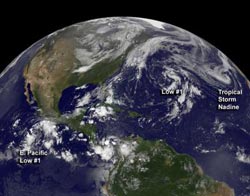
On Sept. 21 at 7:45 a.m. EDT, GOES-13 captured an image of Tropical Storm Nadine in the eastern Atlantic, and developing lows in the central Atlantic and eastern Pacific.<br><br>Credit: NASA/NOAA GOES Project<br>
On Sept. 21 at 7:45 a.m. EDT, NOAA's GOES-13 satellite captured an image of Tropical Storm Nadine in the eastern Atlantic, and a developing low in the central Atlantic. Nadine is south of the frontal boundary draped across the Azores islands. NOAA's GOES-13 satellite sits in a fixed orbit over the eastern U.S. and captures continuous visible and infrared imagery of the eastern U.S. and the Atlantic Ocean. The image was created by NASA's GOES Project, located at NASA's Goddard Space Flight Center in Greenbelt, Md.
NASA's Tropical Rainfall Measuring Mission (TRMM) satellite flew over Tropical Storm Nadine twice on Sept. 21. The first TRMM overpass happened at 0822 UTC (4:22 a.m. EDT) and the second at 1001 UTC (6:01 a.m. EDT). TRMM can see rainfall occurring within a tropical cyclone and noticed that Tropical Storm Nadine's center of circulation has cleared of convection (rising air that forms thunderstorms) and thunderstorms since TRMM passed overhead on Sept. 20. TRMM data on Sept. 21 showed convective rainfall near Nadine's center of circulation had ended and bands of light to moderate rainfall were wrapping around Nadine's southern side. TRMM is a joint mission between NASA and the Japanese Space Agency, and imagery is created at NASA's Goddard Space Flight Center in Greenbelt, Md.
At 1500 UTC (11 a.m. EDT) on Friday, Sept. 21, 2012 Tropical Storm Nadine had maximum sustained winds were near 60 mph (95 kph). The center of Tropical Storm Nadine was located near latitude 34.1 north and longitude 27.5 west, about 270 miles (435 km) south of the Azores islands. Nadine is moving toward the south near 10 mph (17 kmh) and is expected to turn toward the southeast followed by a turn east over the weekend of Sept. 22 and 23. Although there is little change expected in Nadine's intensity over the next day or two, the storm could become post-tropical. Forecasters noted that dry air has moved into the center of Nadine's circulation, sapping the energy in the thunderstorms. In addition, sea surface temperatures are hovering near the 26.6 Celsius (80 degree Fahrenheit) threshold needed to keep a tropical cyclone alive.
The Developing Atlantic Low Pressure Area
There's a non-tropical low pressure area in the central Atlantic Ocean that was also picked up on the GOES-13 satellite image from today, Sept. 21. The low is located about 450 miles east of Bermuda and the shower and thunderstorm activity didn't change much from the previous day. This low is tracking to the north-northwest into cooler waters, which will drop its chances for developing into a sub-tropical depression. In the meantime, it has a 50 percent chance of making it to sub-tropical depression status before hitting the cooler waters.
The Developing Eastern Pacific Low Pressure Area
The low pressure area off the western coast of Mexico has a better chance of development than its Atlantic counterpart, and as a tropical depression, not a sub-tropical one. Satellite data show that the low appears to be getting organized and has a visible appearance of circulation. The low is located about 400 miles south of the southern tip of Manzanillo, Mexico and is moving to the west-northwest. The National Hurricane Center noted that conditions are ripe for development with low wind shear and warm sea surface temperatures. There's a 70 percent chance that this low could become the thirteenth tropical depression of the Eastern Pacific hurricane season. If it develops into a tropical storm over the weekend of Sept. 22 and 23, it would be named Miriam.
Media Contact
More Information:
http://www.nasa.govAll latest news from the category: Earth Sciences
Earth Sciences (also referred to as Geosciences), which deals with basic issues surrounding our planet, plays a vital role in the area of energy and raw materials supply.
Earth Sciences comprises subjects such as geology, geography, geological informatics, paleontology, mineralogy, petrography, crystallography, geophysics, geodesy, glaciology, cartography, photogrammetry, meteorology and seismology, early-warning systems, earthquake research and polar research.


Newest articles

A universal framework for spatial biology
SpatialData is a freely accessible tool to unify and integrate data from different omics technologies accounting for spatial information, which can provide holistic insights into health and disease. Biological processes…

How complex biological processes arise
A $20 million grant from the U.S. National Science Foundation (NSF) will support the establishment and operation of the National Synthesis Center for Emergence in the Molecular and Cellular Sciences (NCEMS) at…

Airborne single-photon lidar system achieves high-resolution 3D imaging
Compact, low-power system opens doors for photon-efficient drone and satellite-based environmental monitoring and mapping. Researchers have developed a compact and lightweight single-photon airborne lidar system that can acquire high-resolution 3D…

