Satellite Shows Atlantic Tropical Depression Degenerate
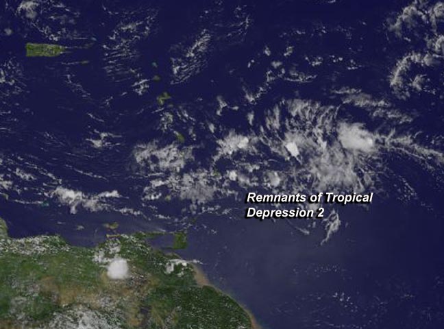
TD2 appeared as just a weak swirl of clouds with no strong thunderstorms or deep convection. Image Credit: NASA/NOAA GOES Project
At 1445 UTC (10:45 a.m. EDT), NOAA's GOES-East satellite captured an image of what was once Tropical Depression 2 (TD2), about 400 miles east of the Lesser Antilles.
The GOES-East visible satellite imagery indicated that the depression weakened since July 22. TD2 appeared as just a weak swirl of clouds with no strong thunderstorms or deep convection.
The GOES image was created by NASA/NOAA's GOES Project at NASA's Goddard Space Flight Center in Greenbelt, Maryland.
In addition, the NHC noted that low-level cloud motions showed no evidence of a closed surface circulation and declared TD2 a remnant low pressure area.
At 11 a.m. EDT (1500 UTC), the National Hurricane Center (NHC) issued their final advisory on TD2, and cited that it had degenerated into a tropical wave.
Despite that, the remnants of the depression are expected to move through the Lesser Antilles this evening (July 23) with some areas of gusty winds and showers, according to the NHC.
The last NHC advisory placed the center of the degenerated depression's center near 14.0 north latitude and 56.0 west longitude, about 365 miles (590 km) east-southeast of the Lesser Antilles.
It was moving quickly to the west at 25 mph (41 kph) and had maximum sustained winds near 35 mph (55 kph) what were quickly waning. TD2's minimum central pressure was near 1012 millibars.
Text credit: Rob Gutro
NASA's Goddard Space Flight Center
Media Contact
All latest news from the category: Earth Sciences
Earth Sciences (also referred to as Geosciences), which deals with basic issues surrounding our planet, plays a vital role in the area of energy and raw materials supply.
Earth Sciences comprises subjects such as geology, geography, geological informatics, paleontology, mineralogy, petrography, crystallography, geophysics, geodesy, glaciology, cartography, photogrammetry, meteorology and seismology, early-warning systems, earthquake research and polar research.


Newest articles

A universal framework for spatial biology
SpatialData is a freely accessible tool to unify and integrate data from different omics technologies accounting for spatial information, which can provide holistic insights into health and disease. Biological processes…

How complex biological processes arise
A $20 million grant from the U.S. National Science Foundation (NSF) will support the establishment and operation of the National Synthesis Center for Emergence in the Molecular and Cellular Sciences (NCEMS) at…

Airborne single-photon lidar system achieves high-resolution 3D imaging
Compact, low-power system opens doors for photon-efficient drone and satellite-based environmental monitoring and mapping. Researchers have developed a compact and lightweight single-photon airborne lidar system that can acquire high-resolution 3D…

