Satellite Sees Tropical Storm Simon Over Baja California
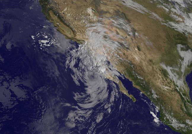
NOAA's GOES-West satellite took a visible picture of Tropical Storm Simon on Oct. 7 at 10:45 a.m. EDT. The image showed Simon's clouds over Baja California and northwestern mainland Mexico. Image Credit: NASA/NOAA GOES Project
On Oct. 7, a Tropical Storm Watch was in effect for Punta Abreojos to Punta Eugenia, Mexico. The National Hurricane Center expects Simon to produce storm total rainfall amounts of 3 to 5 inches with isolated amounts around 8 inches through Wednesday, Oct. 8, across northern portions of the Baja California Peninsula and the state of Sonora in northwestern Mexico. Over the next few days, storm total rainfall amounts of 1 to 2 inches with isolated amounts of around 4 inches are expected across portions of Arizona. This rainfall could cause flash flooding and mud slides.
In addition, winds to tropical storm force are still possible within the Watch area today. Simon continues to generate large swells that will affect portions of the Baja California Peninsula and the coast of southern California today. These swells are likely to cause life-threatening surf and rip current conditions.
NOAA's GOES-West satellite took a visible picture of Tropical Storm Simon on Oct. 7 at 1445 UTC (10:45 a.m. EDT). The image was created by the NASA/NOAA GOES Project at NASA's Goddard Space Flight Center in Greenbelt, Maryland. The image showed Simon's clouds over Baja California and northwestern mainland Mexico. Simon's northernmost clouds stretched into the U.S. southwest. Despite its large appearance, during the morning of Oct. 7, only small area of showers were showing on radar near the north-central Baja California peninsula.
At 11 a.m. EDT (1500 UTC) on Oct. 7, Simon's maximum sustained winds were down to 40 mph (65 kph) and weakening. The center of Tropical Storm Simon was located near latitude 27.7 north and longitude 116.7 west. That's about 100 miles (160 km) west of Punta Eugenia, Mexico. Simon is moving toward the north-northeast near 9 mph (15 kph) and this general motion is expected to continue for the next 24 to 36 hours.
The National Hurricane Center expects Simon to continue weakening and become a remnant low pressure area by Oct. 8. NHC noted that “Simon's surface circulation or its remnant low pressure area is likely to dissipate while it moves into the southwestern United States, unless it fails to survive its passage over the mountainous Baja peninsula during the next day or so.”
Rob Gutro
NASA's Goddard Space Flight Center
Media Contact
All latest news from the category: Earth Sciences
Earth Sciences (also referred to as Geosciences), which deals with basic issues surrounding our planet, plays a vital role in the area of energy and raw materials supply.
Earth Sciences comprises subjects such as geology, geography, geological informatics, paleontology, mineralogy, petrography, crystallography, geophysics, geodesy, glaciology, cartography, photogrammetry, meteorology and seismology, early-warning systems, earthquake research and polar research.


Newest articles

A universal framework for spatial biology
SpatialData is a freely accessible tool to unify and integrate data from different omics technologies accounting for spatial information, which can provide holistic insights into health and disease. Biological processes…

How complex biological processes arise
A $20 million grant from the U.S. National Science Foundation (NSF) will support the establishment and operation of the National Synthesis Center for Emergence in the Molecular and Cellular Sciences (NCEMS) at…

Airborne single-photon lidar system achieves high-resolution 3D imaging
Compact, low-power system opens doors for photon-efficient drone and satellite-based environmental monitoring and mapping. Researchers have developed a compact and lightweight single-photon airborne lidar system that can acquire high-resolution 3D…

