Satellite captures the life and death of Hurricane Sandy on Halloween
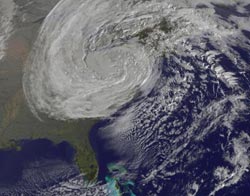
This GOES-13 satellite image was captured on Oct. 31 at 1240 UTC as Sandy's circulation was winding down over Pennsylvania. Sandy had been downgraded a remnant low pressure area.<br><br>Credit: NASA GOES Project<br>
The GOES-13 satellite is managed by the National Oceanic and Atmospheric Administration (NOAA), and NASA's GOES Project at NASA's Goddard Space Flight Center in Greenbelt, Md. creates images and animations from GOES data.
The animation of Sandy's life runs from Oct. 23 through 31. It begins when Tropical Depression 18 strengthened into Hurricane Sandy on Oct. 23, 2012. The animation shows Hurricane Sandy blowing from the Caribbean to the mid-Atlantic where it became wedged between a stationary cold front over the Appalachians and a static high pressure air mass over maritime Canada. The air masses blocked the storm from moving north or east, as it would normally. Instead, their wintery dynamics amplified Sandy and drove it ashore in the mid-Atlantic.
Sandy then became a ferocious Nor'easter that brought record storm surges to coastal N.J. and N.Y., plus blizzard conditions to the mountains. Unprecedented chaos occurred in lower New York City, such as flooding the subway system on the evening of Oct. 29. Total damage by the storm was estimated at $20 billion dollars.
NOAA's National Hydrometeorological Prediction Center (NOAA/HPC) issued an advisory at 5 a.m. EDT on Oct. 31 that stated there was “no discernible surface circulation.” Sandy had weakened to a surface trough (elongated area) of low pressure over western Penn.
There are a lot of warnings and watches in effect as Sandy continues to wind down. Gale warnings and small craft advisories are in effect for portions of the great lakes. Small craft advisories are in effect along much of the Mid-Atlantic and northeast coasts.
Flood and coastal flood watches, warnings and advisories are in effect over portions of the Mid-Atlantic and northeast states. Coastal flooding along portions of the Great Lakes is also possible.
Winter storm warnings and winter weather advisories remain in effect for the mountains of southwest Pennsylvania, western Maryland, West Virginia, eastern Tennessee, eastern Kentucky, and extreme western North Carolina.
Sandy is appropriately dying on Halloween, but the storm's effects will linger for some time.
Media Contact
More Information:
http://www.nasa.govAll latest news from the category: Earth Sciences
Earth Sciences (also referred to as Geosciences), which deals with basic issues surrounding our planet, plays a vital role in the area of energy and raw materials supply.
Earth Sciences comprises subjects such as geology, geography, geological informatics, paleontology, mineralogy, petrography, crystallography, geophysics, geodesy, glaciology, cartography, photogrammetry, meteorology and seismology, early-warning systems, earthquake research and polar research.


Newest articles

A universal framework for spatial biology
SpatialData is a freely accessible tool to unify and integrate data from different omics technologies accounting for spatial information, which can provide holistic insights into health and disease. Biological processes…

How complex biological processes arise
A $20 million grant from the U.S. National Science Foundation (NSF) will support the establishment and operation of the National Synthesis Center for Emergence in the Molecular and Cellular Sciences (NCEMS) at…

Airborne single-photon lidar system achieves high-resolution 3D imaging
Compact, low-power system opens doors for photon-efficient drone and satellite-based environmental monitoring and mapping. Researchers have developed a compact and lightweight single-photon airborne lidar system that can acquire high-resolution 3D…

