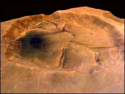
Fractured crater near Valles Marineris
Fractured crater near Valles Marineris <br>
This perspective image of a fractured crater near Valles Marineris on Mars was obtained by the High Resolution Stereo Camera (HRSC) on board the ESA Mars Express spacecraft.
The image was taken during orbit 61 in January 2004 with a resolution of 12. 5 metres per pixel. It shows part of a cratered landscape to the north of the Valles Marineris, at 0.6° S latitude and 309° E longitude, with this crater having a fractured base.
This crater has a rim diameter of 27.5 kilometres and is about 800 metres deep. It is not known yet how these fractures are generated. On Earth, polygonal fractures may occur in contracting material, which breaks at weak zones. For example, we may see this appearing in cooled lava, dried clay or frozen ground.
Media Contact
More Information:
http://www.esa.intAll latest news from the category: Earth Sciences
Earth Sciences (also referred to as Geosciences), which deals with basic issues surrounding our planet, plays a vital role in the area of energy and raw materials supply.
Earth Sciences comprises subjects such as geology, geography, geological informatics, paleontology, mineralogy, petrography, crystallography, geophysics, geodesy, glaciology, cartography, photogrammetry, meteorology and seismology, early-warning systems, earthquake research and polar research.


Newest articles

A universal framework for spatial biology
SpatialData is a freely accessible tool to unify and integrate data from different omics technologies accounting for spatial information, which can provide holistic insights into health and disease. Biological processes…

How complex biological processes arise
A $20 million grant from the U.S. National Science Foundation (NSF) will support the establishment and operation of the National Synthesis Center for Emergence in the Molecular and Cellular Sciences (NCEMS) at…

Airborne single-photon lidar system achieves high-resolution 3D imaging
Compact, low-power system opens doors for photon-efficient drone and satellite-based environmental monitoring and mapping. Researchers have developed a compact and lightweight single-photon airborne lidar system that can acquire high-resolution 3D…

