SMART-1 views Middle East and Mediterranean
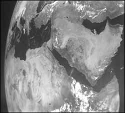
This image of Earth was taken by the AMIE camera on board ESA’s SMART-1 spacecraft on the way to the Moon. Visible from top left, clockwise, Italy, Turkey, the Persian Gulf, the Arabian Peninsula, the Horn of Africa, the Sahara Desert, North Africa and the Mediterranean Sea. Credits: ESA/Space-X
Now more than 100 000 kilometres away from Earth, ESA’s Moon-bound spacecraft SMART-1 looked back at Earth and returned this planetary perspective of the Middle East and Mediterranean Sea.
’Smart’ usage of the solar-electric propulsion system (the ion engine) has saved a lot of fuel and the spacecraft will get to the Moon earlier than expected.
Almost 20 kilograms of the xenon fuel could be saved out of the original 84 kilograms, which could then be used to get closer to the Moon than planned, to within distances of between 300 and 3000 kilometres. This will give a coverage of the lunar surface at higher resolution and sensitivity.
Media Contact
More Information:
http://www.esa.intAll latest news from the category: Earth Sciences
Earth Sciences (also referred to as Geosciences), which deals with basic issues surrounding our planet, plays a vital role in the area of energy and raw materials supply.
Earth Sciences comprises subjects such as geology, geography, geological informatics, paleontology, mineralogy, petrography, crystallography, geophysics, geodesy, glaciology, cartography, photogrammetry, meteorology and seismology, early-warning systems, earthquake research and polar research.


Newest articles

A universal framework for spatial biology
SpatialData is a freely accessible tool to unify and integrate data from different omics technologies accounting for spatial information, which can provide holistic insights into health and disease. Biological processes…

How complex biological processes arise
A $20 million grant from the U.S. National Science Foundation (NSF) will support the establishment and operation of the National Synthesis Center for Emergence in the Molecular and Cellular Sciences (NCEMS) at…

Airborne single-photon lidar system achieves high-resolution 3D imaging
Compact, low-power system opens doors for photon-efficient drone and satellite-based environmental monitoring and mapping. Researchers have developed a compact and lightweight single-photon airborne lidar system that can acquire high-resolution 3D…

