Newborn Tropical Storm Michael struggling like Leslie and Isaac
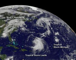
NOAA's GOES-13 satellite captured an image of Isaac's huge blanket of clouds over the US, large Tropical Storm Leslie headed to Bermuda (Leslie is about 400 miles in diameter), and very small Tropical Storm Michael far to the east of Leslie, and located in the central Atlantic. The larger system north of Leslie is a cold-core, low pressure system.<br><br>Credit: NASA GOES Project<br>
Leslie has been a tropical storm since late Aug. and has not yet reached hurricane strength because of wind shear, although that is expected to change. Isaac's remnants are also struggling, but struggling to get off the land and back into the Atlantic Ocean. Isaac's remnants are now associated with a stationary frontal system over the U.S. east coast. The storm made landfall in Louisiana as a hurricane on Aug. 29.
NOAA's GOES-13 satellite captured an image of Isaac's huge blanket of clouds over the U.S., large Tropical Storm Leslie headed to Bermuda (Leslie is about 400 miles in diameter), and very small Tropical Storm Michael far to the east of Leslie, and located in the central Atlantic. Michael is more than seven times smaller than Leslie, as tropical-storm force winds only extend out 35 miles (55 km) from the center, making Michael about 70 miles in diameter. The image was created by the NASA GOES Project at NASA Goddard Space Flight Center in Greenbelt, Md.
On Sept. 4 at 11 a.m. EDT, Michael's maximum sustained winds were near 40 mph (65 kmh). Michael was located about 1,220 miles (1,965 km) southwest of the Azores, near latitude 27.0 north and longitude 43.5 west. Michael is moving toward the north-northwest near 5 mph (7 kmh) and expected to move more toward the north in the next couple of days while not strengthening much, according to the National Hurricane Center.
According to NOAA's Hydrometeorological Prediction Center, most of the remnants of Tropical cyclone Isaac are now part of an elongated center of low pressure over the Alabama-Georgia border that is spreading clouds and showers along the U.S. east coast. That center is expected to move south of south-southwest while an upper level low pressure area near Miami moves north-northwestward.
Media Contact
More Information:
http://www.nasa.govAll latest news from the category: Earth Sciences
Earth Sciences (also referred to as Geosciences), which deals with basic issues surrounding our planet, plays a vital role in the area of energy and raw materials supply.
Earth Sciences comprises subjects such as geology, geography, geological informatics, paleontology, mineralogy, petrography, crystallography, geophysics, geodesy, glaciology, cartography, photogrammetry, meteorology and seismology, early-warning systems, earthquake research and polar research.


Newest articles

A universal framework for spatial biology
SpatialData is a freely accessible tool to unify and integrate data from different omics technologies accounting for spatial information, which can provide holistic insights into health and disease. Biological processes…

How complex biological processes arise
A $20 million grant from the U.S. National Science Foundation (NSF) will support the establishment and operation of the National Synthesis Center for Emergence in the Molecular and Cellular Sciences (NCEMS) at…

Airborne single-photon lidar system achieves high-resolution 3D imaging
Compact, low-power system opens doors for photon-efficient drone and satellite-based environmental monitoring and mapping. Researchers have developed a compact and lightweight single-photon airborne lidar system that can acquire high-resolution 3D…

