New national database of coastal flooding launched
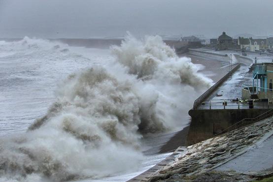
Waves batter the coast at Chesil Beach during the storm of Feb. 4-6, 2015. Credit: Tim Poate and Gerd Masselink
'SurgeWatch' contains information about 96 large storms taken from tide gauge records, which record sea levels back to 1915. It shows the highest sea levels the storms produced and a description of the coastal flooding that occurred during each event.
The database, which is described in the journal Scientific Data, has been produced by a team of researchers, led by the University of Southampton and including scientists from the National Oceanography Centre and the British Oceanographic Data Centre.
Lead author Dr Ivan Haigh, Lecturer in Coastal Oceanography at the University of Southampton, says: “The winter of 2013/14 saw some of the UK's most extreme sea levels, waves and coastal flooding for several decades. During this period storms repeatedly subjected large areas of our coast to enormous stress and damage, reminding us of the real and ever-present risks and challenges facing coastal communities today.”
Professor Kevin Horsburgh, Head of Marine Physics and Ocean Climate at the National Oceanography Centre, says: “This new database allows us to improve our understanding of the statistics of extreme sea levels around the UK. Coastal flooding remains a threat to life and to economic and environmental assets. Even if there is no future change in European storminess, the slow rise in mean sea level will increase the number of times that defence thresholds are exceeded. This database is a useful tool for coastal engineers and planners who are concerned with changes to extreme sea levels.”
SurgeWatch is free and accessible to a range of users, including scientists, coastal engineers, managers and planners. The team aim to expand and update the database and are appealing for the help of the general public.
Dr Matthew Wadey, a postdoctoral researcher in Ocean and Earth Science at the University of Southampton, adds: “Do you have any photographs of coastal flooding from recent or past events, which you are willing to share with us? We would like to compile and investigate these in order to improve our understanding of exactly which areas were flooded and to what water depth. Photos can be easily uploaded to our website.”
Prompted by people asking “Just how unusual was the 2013/14 season?” the researchers spent over 18 months compiling records of high sea level events and coastal flooding going back 100 years. Using meteorological data, they were able to identify the large storms that produced these high sea levels, investigate the weather conditions and track of each storm. They then spent many thousands of hours reading old reports, books, news articles, blogs and websites, to estimate the extent and scale of the coastal flooding.
Elizabeth Bradshaw, data scientist at the British Oceanographic Data Centre, says: “Was the 2013/14 season unusual? Yes, very much so. Seven out of the 96 events in the 100-year database occurred during the 2013-14 storm surge season. Two of the events (5 and 6 December 2013 and 3 January 2014) are ranked in the top ten, in terms of height of sea levels. Both of these events also rank highly in terms of spatial footprints, i.e. they impacted very large stretches of the UK coast.”
Robert Nicholls, Professor of Coastal Engineering at the University of Southampton, adds: “The fact that the damage was so limited during the December 2013 and January 2014 storms, compared to the tragedy of January 1953, during which 307 people were killed along the UK's North Sea coast, is thanks to significant government investment in coastal defences, flood forecasting and sea level monitoring. It is therefore vital we continue to invest in defences, forecasting and monitoring and continue to update this new database.”
Media Contact
All latest news from the category: Earth Sciences
Earth Sciences (also referred to as Geosciences), which deals with basic issues surrounding our planet, plays a vital role in the area of energy and raw materials supply.
Earth Sciences comprises subjects such as geology, geography, geological informatics, paleontology, mineralogy, petrography, crystallography, geophysics, geodesy, glaciology, cartography, photogrammetry, meteorology and seismology, early-warning systems, earthquake research and polar research.


Newest articles

A universal framework for spatial biology
SpatialData is a freely accessible tool to unify and integrate data from different omics technologies accounting for spatial information, which can provide holistic insights into health and disease. Biological processes…

How complex biological processes arise
A $20 million grant from the U.S. National Science Foundation (NSF) will support the establishment and operation of the National Synthesis Center for Emergence in the Molecular and Cellular Sciences (NCEMS) at…

Airborne single-photon lidar system achieves high-resolution 3D imaging
Compact, low-power system opens doors for photon-efficient drone and satellite-based environmental monitoring and mapping. Researchers have developed a compact and lightweight single-photon airborne lidar system that can acquire high-resolution 3D…

