NASA Tracks Tiny Tropical Storm Guchol in Western North Pacific
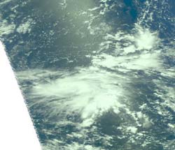
NASA's Aqua satellite passed over Tropical Storm Guchol on June 12 at 0335 UTC and captured a near-infrared image of the storm from the Atmospheric Infrared Sounder (AIRS) instrument. The infrared imagery indicates that convection and thunderstorms are consolidating over the low-level circulation center. Two tightly curved bands of thunderstorms are wrapping into the low-level center from the northeastern and southwestern quadrants of the storm.<br>Credit: NASA/JPL, Ed Olsen <br>
NASA's Aqua satellite passed over Tropical Storm Guchol on June 12 at 0335 UTC and captured a near-infrared image of the storm from the Atmospheric Infrared Sounder (AIRS) instrument. The infrared imagery indicates that convection (rising air that forms thunderstorms) and thunderstorms are consolidating over the low-level circulation center.
Two tightly curved bands of thunderstorms are wrapping into the low-level center from the northeastern and southwestern quadrants of the storm. Satellite imagery indicates that dry air along the northern edge of the storm is preventing thunderstorm formation, which accounts for the slow development of the storm, and the smaller size.
On June 12 at 1500 UTC (11 a.m. EDT/U.S.), Guchol, formerly known as Tropical Depression 05W, has maximum sustained winds near 65 knots (~75 mph/120.4 kph). It is located about 225 nautical miles east of Yap, near 9.7 North and 141.7 East. It is moving to the west at 7 knots (8 mph/13 kph). A tropical storm warning is in effect for Fais and Ulithi in Yap State, Micronesia.
Text Credit: Rob Gutro
NASA Goddard Space Flight Center, Greenbelt, Md.
Media Contact
All latest news from the category: Earth Sciences
Earth Sciences (also referred to as Geosciences), which deals with basic issues surrounding our planet, plays a vital role in the area of energy and raw materials supply.
Earth Sciences comprises subjects such as geology, geography, geological informatics, paleontology, mineralogy, petrography, crystallography, geophysics, geodesy, glaciology, cartography, photogrammetry, meteorology and seismology, early-warning systems, earthquake research and polar research.


Newest articles

Microscopic basis of a new form of quantum magnetism
Not all magnets are the same. When we think of magnetism, we often think of magnets that stick to a refrigerator’s door. For these types of magnets, the electronic interactions…

An epigenome editing toolkit to dissect the mechanisms of gene regulation
A study from the Hackett group at EMBL Rome led to the development of a powerful epigenetic editing technology, which unlocks the ability to precisely program chromatin modifications. Understanding how…

NASA selects UF mission to better track the Earth’s water and ice
NASA has selected a team of University of Florida aerospace engineers to pursue a groundbreaking $12 million mission aimed at improving the way we track changes in Earth’s structures, such…

