NASA sees warmer cloud tops as Tropical Storm Hernan degenerates
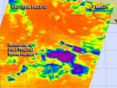
This false-colored infrared image on July 29 at 5:11 a.m. EDT from NASA's Aqua satellite shows small, fragmented areas of a few powerful thunderstorms with high, cold (purple) cloud tops in Tropical Storm Hernan. Credit: NASA JPL, Ed Olsen
The Atmospheric Infrared Sounder or AIRS instrument aboard Aqua gathered infrared data on a quickly weakening Hernan on July 29 at 5:11 a.m. EDT.
The data was then made into a false-colored image at NASA's Jet Propulsion Laboratory in Pasadena, California. The AIRS image showed small, fragmented areas of a few powerful thunderstorms with high, cold cloud tops in Tropical Storm Hernan as it continued weakening.
For the most part, however, the cloud top temperatures warmed through the system which indicated the uplift was weaker.
By 11 a.m. EDT (1500 UTC) Hernan was no longer a tropical cyclone and had become a remnant low pressure area. The center of post-tropical cyclone Hernan was located near latitude 23.5 north and longitude 121.1 west, about 710 miles (1,145 km) west of the southern tip of Baja California, Mexico.
The post-tropical cyclone is moving toward the west-northwest near 15 mph (24 kph) and this general heading with a decrease in forward speed is expected through Wednesday night, July 30. Maximum sustained winds are near 35 mph (55 kph).
The National Hurricane Center expects that remnant low to dissipate during the next couple of days.
Media Contact
All latest news from the category: Earth Sciences
Earth Sciences (also referred to as Geosciences), which deals with basic issues surrounding our planet, plays a vital role in the area of energy and raw materials supply.
Earth Sciences comprises subjects such as geology, geography, geological informatics, paleontology, mineralogy, petrography, crystallography, geophysics, geodesy, glaciology, cartography, photogrammetry, meteorology and seismology, early-warning systems, earthquake research and polar research.


Newest articles

A universal framework for spatial biology
SpatialData is a freely accessible tool to unify and integrate data from different omics technologies accounting for spatial information, which can provide holistic insights into health and disease. Biological processes…

How complex biological processes arise
A $20 million grant from the U.S. National Science Foundation (NSF) will support the establishment and operation of the National Synthesis Center for Emergence in the Molecular and Cellular Sciences (NCEMS) at…

Airborne single-photon lidar system achieves high-resolution 3D imaging
Compact, low-power system opens doors for photon-efficient drone and satellite-based environmental monitoring and mapping. Researchers have developed a compact and lightweight single-photon airborne lidar system that can acquire high-resolution 3D…

