NASA Sees Tropical Storm Raymond Fading Fast
The AIRS instrument aboard NASA's Aqua satellite captured infrared data on Tropical Depression 29W on Oct. 29 at 04:23 UTC/12:23 a.m. EDT and saw strong thunderstorms (purple) west and east of the center. <br>Image Credit: NASA JPL, Ed Olsen<br>
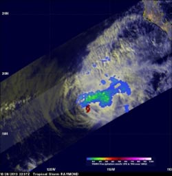
Raymond contained rainfall only in an area northwest of its center of circulation when the Tropical Rainfall Measuring Mission or TRMM satellite passed above on October 28, 2013 at 2337 UTC/4:37 p.m. PDT.
Rainfall data from TRMM's Microwave Imager (TMI) and Precipitation Radar (PR) were combined with a visible and infrared image from TRMM's Visible and InfraRed Scanner (VIRS) to provide an analysis of the storm. The analysis revealed that the maximum rainfall intensity associated with Raymond was only about 33.6mm/~1.3 inches per hour. The TRMM satellite is managed by NASA and JAXA.
The National Hurricane Center noted that Tropical Storm Raymond's maximum sustained winds were down to near 50 mph/85 kph on Oct. 29 at 11 a.m. EDT/1500 UTC. Raymond's center was located near latitude 18.3 north and longitude 116.9 west, about 555 miles/890 km southwest of the southern tip of Baja California, Mexico.
Raymond was moving slowly at 6 mph/9 kph, and is expected to slow more as it weakens over cooler waters tonight, Oct. 29. The NHC expects Raymond to become a remnant low in a day or so.
Text credit: Hal Pierce
SSAI/NASA's Goddard Space Flight Center
Media Contact
All latest news from the category: Earth Sciences
Earth Sciences (also referred to as Geosciences), which deals with basic issues surrounding our planet, plays a vital role in the area of energy and raw materials supply.
Earth Sciences comprises subjects such as geology, geography, geological informatics, paleontology, mineralogy, petrography, crystallography, geophysics, geodesy, glaciology, cartography, photogrammetry, meteorology and seismology, early-warning systems, earthquake research and polar research.


Newest articles

A universal framework for spatial biology
SpatialData is a freely accessible tool to unify and integrate data from different omics technologies accounting for spatial information, which can provide holistic insights into health and disease. Biological processes…

How complex biological processes arise
A $20 million grant from the U.S. National Science Foundation (NSF) will support the establishment and operation of the National Synthesis Center for Emergence in the Molecular and Cellular Sciences (NCEMS) at…

Airborne single-photon lidar system achieves high-resolution 3D imaging
Compact, low-power system opens doors for photon-efficient drone and satellite-based environmental monitoring and mapping. Researchers have developed a compact and lightweight single-photon airborne lidar system that can acquire high-resolution 3D…

