NASA Sees Tropical Depression Polo Winding Down
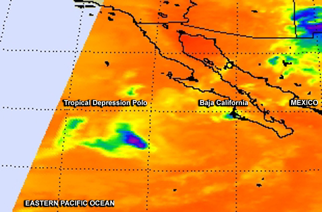
NASA's Aqua satellite gathered infrared data on Polo on Sept. 22 at 5:11 a.m. EDT, reading cloud top temperatures. There was a small area of high clouds (blue), indicating that most thunderstorms had weakened or already dissipated except for that area. Image Credit: NASA JPL, Ed Olsen
The Atmospheric Infrared Sounder or AIRS instrument aboard Aqua gathered infrared data on Polo on Sept. 22 at 5:11 a.m. EDT, reading cloud top temperatures.
There was a small area of high clouds, indicating that most thunderstorms in the depression had weakened or already dissipated except for that area.
At 5 a.m. EDT on Monday, Sept. 22, Tropical Depression Polo's maximum sustained winds have decreased to near 35 mph (55 kph) and additional weakening is forecast during two days. In fact, the National Hurricane Center expects Polo to become a remnant later in the day.
Polo was centered near latitude 22.5 north and longitude 113.8 west, about 250 miles (40 km) west of the southern tip of Baja California.
It was moving toward the west near 8 mph (13 kph) and is expected to turn to the southwest by Sept. 23. Swells generated by polo affecting the southern Baja California peninsula are expected to subside late on Sept. 22.
The National Hurricane Center discussion noted during the morning of Sept. 22 at 5 a.m. EDT that Polo had been devoid of significant deep convection for 10 hours and that the satellite imagery showed the cyclone consisted of “a tight swirl of low-level clouds with a few deeper clouds located over 100 nautical miles west of the center near the mid-level remnants.”
Polo will likely be declared a remnant low late on Sept. 22 and dissipate by Sept. 26.
Rob Gutro NASA's Goddard Space Flight Center
Media Contact
More Information:
http://www.nasa.gov/content/goddard/polo-eastern-pacific/All latest news from the category: Earth Sciences
Earth Sciences (also referred to as Geosciences), which deals with basic issues surrounding our planet, plays a vital role in the area of energy and raw materials supply.
Earth Sciences comprises subjects such as geology, geography, geological informatics, paleontology, mineralogy, petrography, crystallography, geophysics, geodesy, glaciology, cartography, photogrammetry, meteorology and seismology, early-warning systems, earthquake research and polar research.


Newest articles

A universal framework for spatial biology
SpatialData is a freely accessible tool to unify and integrate data from different omics technologies accounting for spatial information, which can provide holistic insights into health and disease. Biological processes…

How complex biological processes arise
A $20 million grant from the U.S. National Science Foundation (NSF) will support the establishment and operation of the National Synthesis Center for Emergence in the Molecular and Cellular Sciences (NCEMS) at…

Airborne single-photon lidar system achieves high-resolution 3D imaging
Compact, low-power system opens doors for photon-efficient drone and satellite-based environmental monitoring and mapping. Researchers have developed a compact and lightweight single-photon airborne lidar system that can acquire high-resolution 3D…

