NASA sees Tropical Depression Nilam blanket southern India
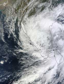
The MODIS instrument that flies aboard NASA's Terra satellite captured this visible image of Tropical Cyclone Nilam over southern India on Nov. 1 at 05:50 UTC (1:50 a.m. EDT).<br><br>Credit: NASA Goddard MODIS Rapid Response Team<br>
On Nov. 1 at 05:50 UTC (1:50 a.m. EDT), the Moderate Resolution Imaging Spectroradiometer (MODIS) instrument that flies aboard NASA's Terra satellite captured a visible image of Tropical Depression Nilam.
The MODIS image showed that Nilam's clouds stretched as far north as Andra Pradesh, a state in east central India. It covered the states of Goa and Karnataka in the west, all the way down to the states of Tamil Nadu, Puducherry and Kerala in extreme southern India.
On Oct. 31 at 1500 UTC (11 a.m. EDT/8:30 p.m. local time, India), Nilam made landfall over southeastern India and started to elongate. When a system is no longer circular and starts to elongate, it begins to weaken.
India's Regional Specialised Meteorological Centre (RSMC) issued a bulletin on Tropical Depression Nilam on Nov. 1 at 2 a.m. EDT (11:30 a.m. local time/India). At that time, Nilam was centered over Rayalaseema. Rayalaseema is a geographic region in the state of Andhra Pradesh. The RSMC noted that Nilam is expected to move northwestward and weaken to a remnant low pressure area later on Nov. 1.
The RSMC expects heavy rainfall over Rayalaseema, Karnataka and south coastal Andhra Pradesh and north Tamilnadu on Nov. 1 and Nov. 2 before the storm dissipates.
Media Contact
More Information:
http://www.nasa.govAll latest news from the category: Earth Sciences
Earth Sciences (also referred to as Geosciences), which deals with basic issues surrounding our planet, plays a vital role in the area of energy and raw materials supply.
Earth Sciences comprises subjects such as geology, geography, geological informatics, paleontology, mineralogy, petrography, crystallography, geophysics, geodesy, glaciology, cartography, photogrammetry, meteorology and seismology, early-warning systems, earthquake research and polar research.


Newest articles

A universal framework for spatial biology
SpatialData is a freely accessible tool to unify and integrate data from different omics technologies accounting for spatial information, which can provide holistic insights into health and disease. Biological processes…

How complex biological processes arise
A $20 million grant from the U.S. National Science Foundation (NSF) will support the establishment and operation of the National Synthesis Center for Emergence in the Molecular and Cellular Sciences (NCEMS) at…

Airborne single-photon lidar system achieves high-resolution 3D imaging
Compact, low-power system opens doors for photon-efficient drone and satellite-based environmental monitoring and mapping. Researchers have developed a compact and lightweight single-photon airborne lidar system that can acquire high-resolution 3D…

