NASA sees Tropical Depression Meari about to cross North Vietnam
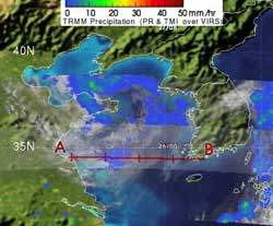
TRMM saw Tropical Depression Meari on June 26 at 1210 UTC (8:10 a.m. EDT) as it neared landfall in North Korea. The yellow and green areas indicate moderate rainfall between .78 to 1.57 inches per hour. There were no red areas seen from TRMM, which usually indicate heavy rainfall. Credit: NASA/SSAI, Hal Pierce<br>
TRMM captured an image of the rainfall in Tropical Depression Meari on June 26 at 1210 UTC (8:10 a.m. EDT). Most of the rainfall was light to moderate in the system, with the heaviest rain near the center of circulation falling at a rate between .78 to 1.57 inches (20 and 40 mm) per hour.
Satellite imagery showed that Meari had become more elongated (because of wind shear) which indicates that the storm is weakening. Between the elongation of the system and the weak convection (lighter rainfall), Meari has lost much of its energy.
On June 27 at 0000 UTC (June 26 at 8 p.m. EDT), the Joint Typhoon Warning Center issued their last advisory on the system. At that time it was about 115 nautical miles west- Northwest of Seoul, South Korea, near 38.3 North latitude and 124.7 East longitude. It was moving to the northeast at 11 knots (13 mph/20 kmh).
The increased wind shear and cooler sea surface temperatures where Meari is now located have taken the steam out of the system. It is expected to fall apart as it crosses over the rough landscape of the Hamgyeong Mountain Range. The remnants of this system may track through North Korea and enter the Sea of Japan. It will be watched for possible regeneration at that time.
Media Contact
More Information:
http://www.nasa.govAll latest news from the category: Earth Sciences
Earth Sciences (also referred to as Geosciences), which deals with basic issues surrounding our planet, plays a vital role in the area of energy and raw materials supply.
Earth Sciences comprises subjects such as geology, geography, geological informatics, paleontology, mineralogy, petrography, crystallography, geophysics, geodesy, glaciology, cartography, photogrammetry, meteorology and seismology, early-warning systems, earthquake research and polar research.


Newest articles

A universal framework for spatial biology
SpatialData is a freely accessible tool to unify and integrate data from different omics technologies accounting for spatial information, which can provide holistic insights into health and disease. Biological processes…

How complex biological processes arise
A $20 million grant from the U.S. National Science Foundation (NSF) will support the establishment and operation of the National Synthesis Center for Emergence in the Molecular and Cellular Sciences (NCEMS) at…

Airborne single-photon lidar system achieves high-resolution 3D imaging
Compact, low-power system opens doors for photon-efficient drone and satellite-based environmental monitoring and mapping. Researchers have developed a compact and lightweight single-photon airborne lidar system that can acquire high-resolution 3D…

