NASA sees Tropical Cyclone Winston threatening Tonga and American Samoa
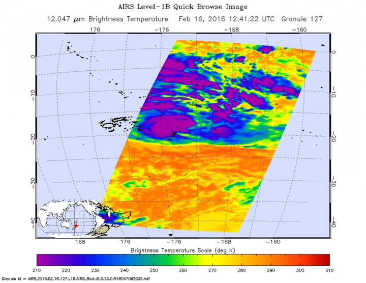
On Feb. 16 the AIRS instrument aboard NASA's Aqua satellite saw cloud top temperatures in strong thunderstorms exceeding -63F/-53C (purple) around the center of circulation. Credits: NASA JPL, Ed Olsen
On Feb.16 a gale warning was in effect for Niue. In Tonga, a storm warning was in effect for Vavau and a gale warning was in effect for Ha'apai, Niuafo'ou and Niuatoputapu.
On Feb. 16 at 1500 UTC (10 a.m. EST) Tropical cyclone Winston's maximum sustained winds had increased to hurricane-force after spending several days as a tropical storm. Winds were near 65 knots (74.8 mph/120.4 kph). Winston was centered near 17.9 degrees south latitude and 173.6 degrees west longitude, about 273 nautical miles (314 miles/505 km) southwest of Pago Pago, American Samoa. Winston was moving to the northeast at 10 knots (11.5 mph/18.5 kph).
On Feb. 16 the Atmospheric Infrared Sounder (AIRS) instrument aboard Aqua saw cloud top temperatures exceeding -63 degrees Fahrenheit (-53 degrees Celsius) around the 23 nautical-mile wide eye. Storms with cloud tops that cold are very high into the troposphere and have the capability of producing heavy rainfall.
The Joint Typhoon Warning Center noted “Winston is currently positioned in a good environment for intensification with favorable sea surface temperatures and low vertical wind shear.
JTWC expects Winston to move northeast and start to re-strengthen. The storm is forecast to peak at 100 knots (115.1 mph/185.2 kph) by Feb. 17 and 18, south of American Samoa, before turning back west.
Media Contact
All latest news from the category: Earth Sciences
Earth Sciences (also referred to as Geosciences), which deals with basic issues surrounding our planet, plays a vital role in the area of energy and raw materials supply.
Earth Sciences comprises subjects such as geology, geography, geological informatics, paleontology, mineralogy, petrography, crystallography, geophysics, geodesy, glaciology, cartography, photogrammetry, meteorology and seismology, early-warning systems, earthquake research and polar research.


Newest articles

A universal framework for spatial biology
SpatialData is a freely accessible tool to unify and integrate data from different omics technologies accounting for spatial information, which can provide holistic insights into health and disease. Biological processes…

How complex biological processes arise
A $20 million grant from the U.S. National Science Foundation (NSF) will support the establishment and operation of the National Synthesis Center for Emergence in the Molecular and Cellular Sciences (NCEMS) at…

Airborne single-photon lidar system achieves high-resolution 3D imaging
Compact, low-power system opens doors for photon-efficient drone and satellite-based environmental monitoring and mapping. Researchers have developed a compact and lightweight single-photon airborne lidar system that can acquire high-resolution 3D…

