NASA sees Super Typhoon Namadol explode in strength, Talas also strengthens
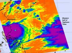
This infrared image of Super Typhoon Nanmadol's very cold cloud top temperatures point to where the strongest storms are (purple) within Nanmadol. The AIRS instrument on NASA's Aqua satellite captured this image on Aug. 26 at 12:47 a.m. EDT. The cloud mass at the eastern edge of the image is the western half of Tropical Storm Talas, a Category One Typhoon which is very large in extent. Credit: NASA/JPL, Ed Olsen<br>
NASA's Aqua satellite provided two different perspectives of this supertyphoon: a visible and an infrared. The Moderate Resolution Imaging Spectroradiometer (MODIS) instrument on NASA's Aqua satellite captured a visible image of Super Typhoon Nanmadol over the Philippines at 12:50 a.m. EDT (4:50 UTC).
The Atmospheric Infrared Sounder (AIRS) is the instrument on Aqua that took an infrared image of Nanmadol's and nearby Tropical Storm Talas' cloud top temperatures on August 26 at 12:47 a.m. EDT. AIRS infrared image revealed that the super typhoon has highly symmetrical bands of thunderstorms wrapping tightly into its eye. Nanmadol has an eye that is 18 nautical miles (21 miles/33 km) in diameter. Tropical Storm Talas, located to the northeast of Nanmadol.
At 11 a.m. EDT (1500 UTC) on August 26, Super Typhoon Nanmadol's maximum sustained winds were near 135 knots (155 mph/250 kmh) with higher gusts making it the top end of the Category four typhoon status. Category five typhoons have sustained wind speeds of greater than 155 mph (135 knots).
Nanmadol was about 585 nautical miles (673 miles/1083 km) south-southwest of Kadena Air Base, Japan and northeast of Luzon, Philippines where it was dropping heavy rainfall. Nanmadol is moving to the north-northwest at 6 knots and is generating dangerous surf with wave heights reaching 32 feet (.7 meters)!
Forecasters at the Joint Typhoon Warning Center (JTWC) expect Nanmadol to intensify further into a Category Five Typhoon then gradually weaken. Nanmadol is expected to continue skirting Luzon, passing it on August 27, then passing to the east of Taiwan on August 28 and 29. Taiwan can also expect very rough seas, gusty winds and heavy downpours as Nanmadol passes by and heads to the northwest next week.
At the same time, and much farther to the northeast, Tropical Storm Talas had maximum sustained winds near 45 knots (52 mph/83 kmh). It was located about 185 nautical miles (212 miles/ 342 km) south-southwest of the island of Iwo Two, Japan near 22.3 North and 139.8 East. It was moving to the north-northwest near 6 knots (7 mph/11 kmh) and also generating rough seas, 22 feet high (6.7 meters). The AIRS infrared data showed bands of strong convection wrapping around the northeastern edge of the center, indicating strengthening.
The JTWC forecast calls for Talas to steadily intensify over the weekend because of warm sea surface temperatures and favorable upper level atmospheric conditions. Talas is expected to take a more northerly track and pass just to the west of Iwo To over the weekend, and past Chichi Jima on Monday, August 29.
It is going to be a busy weekend in the western North Pacific Ocean with strengthening Super Typhoon Nanmadol and a strengthening Tropical Storm Talas.
Media Contact
More Information:
http://www.nasa.govAll latest news from the category: Earth Sciences
Earth Sciences (also referred to as Geosciences), which deals with basic issues surrounding our planet, plays a vital role in the area of energy and raw materials supply.
Earth Sciences comprises subjects such as geology, geography, geological informatics, paleontology, mineralogy, petrography, crystallography, geophysics, geodesy, glaciology, cartography, photogrammetry, meteorology and seismology, early-warning systems, earthquake research and polar research.


Newest articles

Simplified diagnosis of rare eye diseases
Uveitis experts provide an overview of an underestimated imaging technique. Uveitis is a rare inflammatory eye disease. Posterior and panuveitis in particular are associated with a poor prognosis and a…

Targeted use of enfortumab vedotin for the treatment of advanced urothelial carcinoma
New study identifies NECTIN4 amplification as a promising biomarker – Under the leadership of PD Dr. Niklas Klümper, Assistant Physician at the Department of Urology at the University Hospital Bonn…

A novel universal light-based technique
…to control valley polarization in bulk materials. An international team of researchers reports in Nature a new method that achieves valley polarization in centrosymmetric bulk materials in a non-material-specific way…

