NASA sees the short life of Tropical Depression John
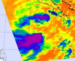
NASA's Aqua satellite flew over John on Sept. 3 at 2041 UTC (4:41 p.m. EDT) during its brief time as a tropical storm and noticed the strongest convection (purple) and coldest cloud top temperatures seemed to be limited to the northeastern and southwestern quadrants of the storm.<br><br>Credit: NASA JPL, Ed Olsen<br>
NASA's Aqua satellite flew over John on Sept. 3 at 2041 UTC (4:41 p.m. EDT) during its brief time as a tropical storm and noticed convection (rising air that forms thunderstorms that make up the storm) and coldest cloud top temperatures seemed to be limited to the northeastern and southwestern quadrants of the storm. As John continued to move north into cooler waters the convection tapered off, and the development of strong thunderstorms diminished.
By Tuesday, September 04, 2012 at 2 a.m. EDT, there was no sign of strong convection in John and the storm had become “a swirl of low- to mid-level clouds,” according to the National Hurricane Center.
At 11 a.m. EDT today, Tropical Depression John's maximum sustained winds were near 35 mph (55 kmh) and the storm is weakening. It was centered about 420 miles (620 km) west of the southernmost tip of Baja California, near 23.5 North and 116.5 West. John was moving to the northwest near 14 mph (22 kmh) and is expected to keep moving in that general direction while slowing over the cooler waters.
John's fame is fleeting as the tropical depression is expected to become a remnant area of low pressure later today, Sept. 4.
Media Contact
More Information:
http://www.nasa.govAll latest news from the category: Earth Sciences
Earth Sciences (also referred to as Geosciences), which deals with basic issues surrounding our planet, plays a vital role in the area of energy and raw materials supply.
Earth Sciences comprises subjects such as geology, geography, geological informatics, paleontology, mineralogy, petrography, crystallography, geophysics, geodesy, glaciology, cartography, photogrammetry, meteorology and seismology, early-warning systems, earthquake research and polar research.


Newest articles

A universal framework for spatial biology
SpatialData is a freely accessible tool to unify and integrate data from different omics technologies accounting for spatial information, which can provide holistic insights into health and disease. Biological processes…

How complex biological processes arise
A $20 million grant from the U.S. National Science Foundation (NSF) will support the establishment and operation of the National Synthesis Center for Emergence in the Molecular and Cellular Sciences (NCEMS) at…

Airborne single-photon lidar system achieves high-resolution 3D imaging
Compact, low-power system opens doors for photon-efficient drone and satellite-based environmental monitoring and mapping. Researchers have developed a compact and lightweight single-photon airborne lidar system that can acquire high-resolution 3D…

