NASA sees more severe weather over eastern Texas, Oklahoma
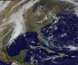
NOAA's GOES-13 satellite captured a visible image of the clouds associated with the stalled front over eastern Texas and Oklahoma on March 20, 2012 at 1731 UTC (1:31 pm EST). Ironically, the clouds look almost like a giant funnel. Credit: NASA/NOAA GOES Project<br>
NASA's Aqua satellite and NOAA's GOES-13 satellite have been providing infrared, visible and microwave images to forecasters of the stalled frontal system.
On March 20, a flood warning was in effect up and down the eastern sides of Texas and Oklahoma, including Dallas and Fort Worth, Texas. The National Weather Service posted a flood warning for the double cities because of heavy rainfall over the last 36 hours. More isolated thunderstorms are expected to develop late afternoon and evening, generating more heavy rainfall, lightning and small hail.
When NASA's Aqua satellite flew over the low pressure area on March 20 at 0753 UTC 34:53 a.m. EST), the Atmospheric Infrared Sounder (AIRS) instrument onboard captured an infrared image that showed cloud top temperatures in the frontal system. The strongest thunderstorms, heaviest rainfall and coldest cloud top temperatures (around 220 Kelvin/ -63.6 F/-53.1 C) appeared as a giant wedge over the region.
NASA's Goddard Space Flight Center in Greenbelt, Md. uses data from the National Oceanic and Atmospheric Administration's (NOAA's) GOES-13 satellite's and creates images and animations. NOAA's GOES-13 satellite captured a visible image of the clouds associated with the stalled front over eastern Texas and Oklahoma on March 20, 2012 at 1731 UTC (1:31 p.m. EDT). Ironically, the clouds look almost like a giant funnel.
Media Contact
More Information:
http://www.nasa.govAll latest news from the category: Earth Sciences
Earth Sciences (also referred to as Geosciences), which deals with basic issues surrounding our planet, plays a vital role in the area of energy and raw materials supply.
Earth Sciences comprises subjects such as geology, geography, geological informatics, paleontology, mineralogy, petrography, crystallography, geophysics, geodesy, glaciology, cartography, photogrammetry, meteorology and seismology, early-warning systems, earthquake research and polar research.


Newest articles

A universal framework for spatial biology
SpatialData is a freely accessible tool to unify and integrate data from different omics technologies accounting for spatial information, which can provide holistic insights into health and disease. Biological processes…

How complex biological processes arise
A $20 million grant from the U.S. National Science Foundation (NSF) will support the establishment and operation of the National Synthesis Center for Emergence in the Molecular and Cellular Sciences (NCEMS) at…

Airborne single-photon lidar system achieves high-resolution 3D imaging
Compact, low-power system opens doors for photon-efficient drone and satellite-based environmental monitoring and mapping. Researchers have developed a compact and lightweight single-photon airborne lidar system that can acquire high-resolution 3D…

