NASA Sees Remnants of Tropical Cyclone Hadi in So. Pacific
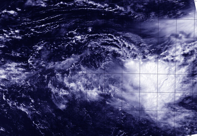
NASA's Aqua satellite flew over Hadi's remnants on March 12 and the MODIS aboard captured a visible image that showed the strongest thunderstorms associated with the low appeared south of the center of circulation. Image Credit: NRL/NASA
When NASA's Aqua satellite flew over Hadi's remnants, the MODIS instrument aboard captured a visible image that showed the strongest thunderstorms associated with the low appeared south of the center of circulation.
The center was located near 15.1 south and 156.1 east, about 585 nautical miles/673.2 miles/ 1,083 km west of Vanuatu.
The Joint Typhoon Warning Center or JTWC noted that animated multispectral satellite imagery depicts an exposed, well-defined low-level circulation center with persistent deep convection over the southern semi-circle.
The Special Sensor Microwave Imager aboard the Defense Meteorological Satellite Program satellite showed that the low-level center of circulation is elongated, and there are shallow bands of thunderstorms over the southern quadrant.
The JTWC noted on March 12, “Based on the lack of convective structure, marginal environment and weak model development, the potential for the development of a significant tropical cyclone within the next 24 hours is downgraded to low.”
Text credit: Rob Gutro
NASA's Goddard Space Flight Center
Media Contact
All latest news from the category: Earth Sciences
Earth Sciences (also referred to as Geosciences), which deals with basic issues surrounding our planet, plays a vital role in the area of energy and raw materials supply.
Earth Sciences comprises subjects such as geology, geography, geological informatics, paleontology, mineralogy, petrography, crystallography, geophysics, geodesy, glaciology, cartography, photogrammetry, meteorology and seismology, early-warning systems, earthquake research and polar research.


Newest articles

A universal framework for spatial biology
SpatialData is a freely accessible tool to unify and integrate data from different omics technologies accounting for spatial information, which can provide holistic insights into health and disease. Biological processes…

How complex biological processes arise
A $20 million grant from the U.S. National Science Foundation (NSF) will support the establishment and operation of the National Synthesis Center for Emergence in the Molecular and Cellular Sciences (NCEMS) at…

Airborne single-photon lidar system achieves high-resolution 3D imaging
Compact, low-power system opens doors for photon-efficient drone and satellite-based environmental monitoring and mapping. Researchers have developed a compact and lightweight single-photon airborne lidar system that can acquire high-resolution 3D…

