NASA Sees Heavy Rainfall as Typhoon Rumbia Heads for Landfall in China
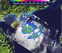
NASA’s TRMM satellite flew over Rumbia on July 1 at 12:12 a.m. EDT and noticed some areas of heavy rainfall (red) in bands of thunderstorms south of the center. Heavy rainfall was falling at rates of over 2 inches/50 mm per hour. Strong band of thunderstorms continued.<br>Image Credit: SSAI/NASA, Hal Pierce<br>
On Sunday, June 30, NASA infrared satellite imagery revealed tightly curved bands of thunderstorms over the southern quadrant of the storm were wrapping into the northern quadrant of the low-level center. However, in the northwestern quadrant, the quadrant that will make landfall first, there was a lack of strong convection and thunderstorms. Those satellite observations held true 24 hours later.
Typhoon Rumbia was located east of Hainan Island, China in South China Sea early on July 1. It is headed for landfall today, July 1, in southeastern China, south of Hong Kong.
When NASA’s Tropical Rainfall Measuring Mission or TRMM satellite flew over Rumbia on July 1 at 0412 UTC (12:12 a.m. EDT) the Precipitation Radar instrument noticed some areas of heavy rainfall in bands of thunderstorms south of the center of circulation. Heavy rainfall was falling at rates of over 2 inches/50 mm per hour. TRMM imagery continued to show the strong band of thunderstorms continued wrapping around the southern quadrant of the storm and into the low-level center.
On July 1 at 1500 UTC (11 a.m. EDT), Rumbia’s maximum sustained winds increased from 45 knots (52 mph) to 65 knots (74 mph/120 kph) making it a minimal typhoon. It was located near 20.3 north latitude and 110.9 east longitude, about 217 nautical miles southwest of Hong Kong. Rumbia is moving to the west-northwest at 13 knots (15 mph/24 kph).
Rumbia’s western quadrant is already interacting with the land of Hainan Island, China, breaking up the band of thunderstorms in that part of the storm. Because the interaction with land is already weakening the storm the forecasters at the Joint Typhoon Warning Center (JTWC) expect Rumbia to continue to weaken as it heads for landfall.
JTWC expects that Rumbia may make landfall near Zhanjiang, a prefecture-level city at the southwestern end of Guangdong province. Areas that Rumbia’s center are expected to pass near include Leizhou Bay and Zhanjiang Port.
Residents along southeastern China are already feeling the effects of Rumbia with tropical-storm force winds, heavy rainfall, flash flooding and very rough surf along the coasts.
Rob Gutro
NASA’s Goddard Space Flight Center
Media Contact
All latest news from the category: Earth Sciences
Earth Sciences (also referred to as Geosciences), which deals with basic issues surrounding our planet, plays a vital role in the area of energy and raw materials supply.
Earth Sciences comprises subjects such as geology, geography, geological informatics, paleontology, mineralogy, petrography, crystallography, geophysics, geodesy, glaciology, cartography, photogrammetry, meteorology and seismology, early-warning systems, earthquake research and polar research.


Newest articles

A universal framework for spatial biology
SpatialData is a freely accessible tool to unify and integrate data from different omics technologies accounting for spatial information, which can provide holistic insights into health and disease. Biological processes…

How complex biological processes arise
A $20 million grant from the U.S. National Science Foundation (NSF) will support the establishment and operation of the National Synthesis Center for Emergence in the Molecular and Cellular Sciences (NCEMS) at…

Airborne single-photon lidar system achieves high-resolution 3D imaging
Compact, low-power system opens doors for photon-efficient drone and satellite-based environmental monitoring and mapping. Researchers have developed a compact and lightweight single-photon airborne lidar system that can acquire high-resolution 3D…

