NASA sees heavy rain in Arabian Sea tropical cyclone
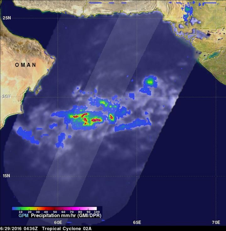
On June 29, GPM showed Tropical Cyclone 02A had a few powerful convective thunderstorms southwest of the center of circulation were dropping rain at the extreme rate of over 209 mm (8.2 inches) per hour. Credits: NASA/JAXA/SSAI, Hal Pierce
On June 28 at 1800 UTC (2 p.m. EDT) the Joint Typhoon Warning Center issued its final bulletin on Tropical Cyclone 02A.
At that time, the storm had weakened to a depression with maximum sustained winds near 30 knots. It was located about 248 nautical miles east of Masirah Island, Oman. The depression was moving to the south-southwest at 2 knots and weakening.
The GPM core observatory satellite provided an excellent look at rainfall near the tropical cyclone when it passed above on June 29, 2016 at 0436 UTC (12:36 a.m. EDT).
Data collected by GPM's Microwave Imager (GMI) and Dual-Frequency Precipitation Radar (DPR) instruments showed that a few powerful convective thunderstorms southwest of the weakening tropical cyclone's center of circulation were dropping rain at the extreme rate of over 209 mm (8.2 inches) per hour.
The lighter shaded swath on the GPM satellite view indicates the area covered by GPM's radar.
The GPM satellite's Radar (DPR Ku Band) can be used to examine the 3-D structure of precipitation. Several storm tops of energetic thunderstorms southwest of the weakening tropical cyclone were measured by DPR reaching heights of over 15 km (9.3 miles).
The Joint Typhoon Warning Center expects the depression to dissipate by June 30.
Media Contact
All latest news from the category: Earth Sciences
Earth Sciences (also referred to as Geosciences), which deals with basic issues surrounding our planet, plays a vital role in the area of energy and raw materials supply.
Earth Sciences comprises subjects such as geology, geography, geological informatics, paleontology, mineralogy, petrography, crystallography, geophysics, geodesy, glaciology, cartography, photogrammetry, meteorology and seismology, early-warning systems, earthquake research and polar research.


Newest articles

A universal framework for spatial biology
SpatialData is a freely accessible tool to unify and integrate data from different omics technologies accounting for spatial information, which can provide holistic insights into health and disease. Biological processes…

How complex biological processes arise
A $20 million grant from the U.S. National Science Foundation (NSF) will support the establishment and operation of the National Synthesis Center for Emergence in the Molecular and Cellular Sciences (NCEMS) at…

Airborne single-photon lidar system achieves high-resolution 3D imaging
Compact, low-power system opens doors for photon-efficient drone and satellite-based environmental monitoring and mapping. Researchers have developed a compact and lightweight single-photon airborne lidar system that can acquire high-resolution 3D…

