NASA Sees First Eastern Pacific Tropical Depression to Open Season
NASA’s Aqua satellite flew over Tropical Depression 1-E (TD1E) at 0823 UTC (4:23 a.m. EDT) and the Atmospheric Infrared Sounder (AIRS) instrument captured an infrared image of the storm. AIRS data showed bands of thunderstorms wrapping into the low-level center from the west, as well as a fragmented band of thunderstorms east of center. Credit: NASA JPL/Ed Olsen<br>
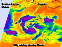
The first tropical depression formed around 11 a.m. EDT on May 15. NASA’s Aqua satellite flew over Tropical Depression 1-E (TD1E) at 0823 UTC (4:23 a.m. EDT) and the Atmospheric Infrared Sounder (AIRS) instrument captured an infrared image of the storm.
AIRS data showed bands of thunderstorms wrapping into the low-level center from the west, as well as a fragmented band of thunderstorms east of center. Cloud top temperatures of the thunderstorms were as cold as -63 Fahrenheit (-52 Celsius) indicating strong thunderstorms with heavy rainfall potential.
At 11 a.m. EDT on May 15, TD1E had maximum sustained winds near 35 mph (55 kph). It was located far from land, about 650 miles (1,045 km) south-southwest of Acapulco, Mexico, near 9.2 north latitude and 103.6 west longitude. TD1E was moving to the west at 12 mph (19 kph) and had a minimum central pressure near 1006 millibars. There are no coastal warnings or watches in effect.
The National Hurricane Center noted that TD1E will be moving through warm waters over the next couple of days, which will likely strengthen it into Tropical Storm Alvin.
Text credit: Rob Gutro
NASA’s Goddard Space Flight Center
Media Contact
All latest news from the category: Earth Sciences
Earth Sciences (also referred to as Geosciences), which deals with basic issues surrounding our planet, plays a vital role in the area of energy and raw materials supply.
Earth Sciences comprises subjects such as geology, geography, geological informatics, paleontology, mineralogy, petrography, crystallography, geophysics, geodesy, glaciology, cartography, photogrammetry, meteorology and seismology, early-warning systems, earthquake research and polar research.


Newest articles

A universal framework for spatial biology
SpatialData is a freely accessible tool to unify and integrate data from different omics technologies accounting for spatial information, which can provide holistic insights into health and disease. Biological processes…

How complex biological processes arise
A $20 million grant from the U.S. National Science Foundation (NSF) will support the establishment and operation of the National Synthesis Center for Emergence in the Molecular and Cellular Sciences (NCEMS) at…

Airborne single-photon lidar system achieves high-resolution 3D imaging
Compact, low-power system opens doors for photon-efficient drone and satellite-based environmental monitoring and mapping. Researchers have developed a compact and lightweight single-photon airborne lidar system that can acquire high-resolution 3D…

