NASA sees a hot tower in first tropical depression of the eastern Pacific
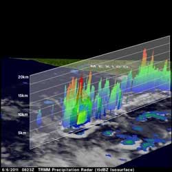
Tropical Depression 1E is small but thunderstorm "Hot Towers" have reached heights of about 16 km (~9.9 miles) indicating some strong convection (red) around the storm's center. Credit: SSAI/NASA Goddard, Hal Pierce<br>
Tropical Depression 1E formed when the low pressure area called System 91E strengthened overnight. Today, June 7, Tropical Depression 1E (TD1E) was located about 365 miles (590 km) south of Acapulco, Mexico near 11.6 North and 100.0 West. It had maximum sustained winds near 30 mph (45 kmh) and was moving to the northwest near 3 mph (6 kmh). Minimum central pressure was near 1006 millibars.
When TRMM passed over TD1E yesterday morning (it was still System 91E at that time) at 0823 UTC (4:23 p.m. EDT) its precipitation radar instrument analyzed the rainfall rates The majority of rainfall occurring at that time was moderate between .78 to 1.57 inches (20-40 mm) per hour, with some isolated areas of heavy rainfall, falling at almost 2 inches (50 mm) per hour.
More importantly, TRMM noticed some of the thunderstorms around the center of circulation were actually what is called “hot towers.”
A hot tower is a rain cloud that reaches at least to the top of the troposphere, the lowest layer of the atmosphere. It extends approximately nine miles (14.5 km) high in the tropics. These towers are called “hot” because they rise to such altitude due to the large amount of latent heat. Water vapor releases this latent heat as it condenses into liquid. They're also indicative of a lot of energy within a tropical depression. In the case of Tropical Depression 1E, some of the hot towers reached heights of 16 km (~9.9 miles).
The National Hurricane Center forecasts TD1E to intensify and continue moving in an north-northwesterly direction, steering away from land.
Media Contact
More Information:
http://www.Nasa.govAll latest news from the category: Earth Sciences
Earth Sciences (also referred to as Geosciences), which deals with basic issues surrounding our planet, plays a vital role in the area of energy and raw materials supply.
Earth Sciences comprises subjects such as geology, geography, geological informatics, paleontology, mineralogy, petrography, crystallography, geophysics, geodesy, glaciology, cartography, photogrammetry, meteorology and seismology, early-warning systems, earthquake research and polar research.


Newest articles

A universal framework for spatial biology
SpatialData is a freely accessible tool to unify and integrate data from different omics technologies accounting for spatial information, which can provide holistic insights into health and disease. Biological processes…

How complex biological processes arise
A $20 million grant from the U.S. National Science Foundation (NSF) will support the establishment and operation of the National Synthesis Center for Emergence in the Molecular and Cellular Sciences (NCEMS) at…

Airborne single-photon lidar system achieves high-resolution 3D imaging
Compact, low-power system opens doors for photon-efficient drone and satellite-based environmental monitoring and mapping. Researchers have developed a compact and lightweight single-photon airborne lidar system that can acquire high-resolution 3D…

