NASA sees 2 tropical cyclones in Eastern Pacific
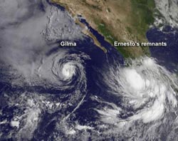
NOAA's GOES-15 satellite captured an image of Tropical Storm Gilma (left) in the eastern Pacific Ocean, with the remnant low pressure area, formerly Tropical Storm Ernesto (right), about to move into the Pacific.<br><br>Credit: NASA GOES Project<br>
On August 10, NOAA's GOES-15 satellite captured Tropical Storm Gilma and a low pressure area that was once the Atlantic Basin's Tropical storm Ernesto, now moving off the western Mexican coast.
NASA's GOES Project, located at NASA Goddard Space Flight Center in Greenbelt, Md. has been busy creating images and animations of Tropical Storm Gilma and the remnants of Tropical Storm Ernesto as it crosses Mexico from the Gulf of Mexico and has begun its entrance into the Eastern Pacific Ocean.
NASA's GOES Project uses data from NOAA's Geostationary Operational Environmental Satellites (GOES), and the GOES-15 satellite covers the Eastern Pacific Ocean basin and the eastern U.S. from a fixed orbit. GOES-15 provides continuous data that NASA makes into images and animations. An image captured on August 10, 2012 at 1500 UTC (11:00 a.m. EDT) shows Ernesto's clouds lingering over the western coast of Mexico and Gilma out over open waters.
At 11 a.m. EDT on August 10, Tropical Storm Gilma's maximum sustained winds were near 65 mph (100 kmh). The National Hurricane Center (NHC) expects Gilma to weaken over the next two days because of an increase in vertical wind shear and movement into cooler waters. The National Hurricane Center expects Gilma to become a tropical depression sometime on August 11. Gilma was centered about 670 miles (1,080 km) west-southwest of the southern tip of Baja California near latitude 18.8 north and longitude 119.3 west. Gilma is moving toward the north-northwest near 5 mph (7 kmh) and is motion is expected to continue over the next day or so.
Behind Gilma, and located along the southern coast of Mexico is a large area of showers and thunderstorms associated with the broad circulation of weakening tropical depression Ernesto. Because environmental conditions are favorable, the low, formerly known as Ernesto, has a 60 percent chance of developing into a tropical depression is it moves westward and into the open waters of the Eastern Pacific Ocean. Once it becomes a tropical depression and if it strengthens to a tropical storm, it would get a new name.
Media Contact
More Information:
http://www.nasa.govAll latest news from the category: Earth Sciences
Earth Sciences (also referred to as Geosciences), which deals with basic issues surrounding our planet, plays a vital role in the area of energy and raw materials supply.
Earth Sciences comprises subjects such as geology, geography, geological informatics, paleontology, mineralogy, petrography, crystallography, geophysics, geodesy, glaciology, cartography, photogrammetry, meteorology and seismology, early-warning systems, earthquake research and polar research.


Newest articles

A universal framework for spatial biology
SpatialData is a freely accessible tool to unify and integrate data from different omics technologies accounting for spatial information, which can provide holistic insights into health and disease. Biological processes…

How complex biological processes arise
A $20 million grant from the U.S. National Science Foundation (NSF) will support the establishment and operation of the National Synthesis Center for Emergence in the Molecular and Cellular Sciences (NCEMS) at…

Airborne single-photon lidar system achieves high-resolution 3D imaging
Compact, low-power system opens doors for photon-efficient drone and satellite-based environmental monitoring and mapping. Researchers have developed a compact and lightweight single-photon airborne lidar system that can acquire high-resolution 3D…

