NASA Satellites See Tropical Cyclone Irina Headed for Mozambique
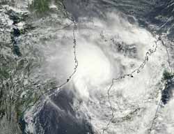
NASA's Aqua satellite's MODIS instrument captured this visible image of Tropical Cyclone Irina over the Mozambique Channel on February 29, 2012 at 1100 UTC (6 a.m. EST).<br>Credit: NASA Goddard MODIS Rapid Response Team <br>
The low pressure area called System 92S that tracked across northern Madagascar this week and brought flooding rains has moved into the Mozambique Channel, strengthen and has been renamed Irina. NASA satellites captured a visible image of Irina as it filled up the northern half of the Mozambique Channel.
System 92S strengthened into Cyclone Irina off Cape St Andre, Madagascar after moving across the northern half of the country as a soaking low pressure area. Now in the warm waters of the Mozambique Channel (the body of water between the island nation of Madagascar and Mozambique on the African mainland), it is strengthening and moving to the west.
NASA's Aqua satellite's MODIS instrument captured a visible image of Tropical Cyclone Irina over the Mozambique Channel on February 29, 2012 at 1100 UTC (6 a.m. EST). It showed the center of Irina in the northern Mozambique Channel and its clouds extended from Mozambique in the west across the channel to Madagascar.
The Atmospheric Infrared Sounder (AIRS) instrument showed another view of the storm: one in infrared light. Infrared light helps determine temperatures of cloud tops and sea surface temperatures, two factors important in tropical cyclones. Warm sea surface temperatures in excess of 26.6 Celsius (80 Fahrenheit) help maintain a cyclone. The warmer the sea surface, the more energy gets fed (evaporation and moisture) into a tropical cyclone, helping it grow stronger. Sea surface temperatures in the Mozambique Channel are near 29 Celsius (84F), which is helping Cyclone Irina develop and strengthen.
The cloud-top temperatures need to be the opposite of sea surface temperatures to indicate strengthening. The colder the cloud top temperatures, the higher and stronger the thunderstorms are that make up the tropical cyclone (a cyclone/hurricane is made up of hundreds of thunderstorms).
Infrared satellite imagery allows forecasters to see where some of the most powerful thunderstorms are in a tropical cyclone. AIRS infrared data has observed that Irina's cloud top temperatures have grown colder since yesterday, February 28, indicating more strength in the storm. North of Irina's center, cloud top temperatures are now colder than -63 Fahrenheit (-52.7C), a threshold in AIRS data that indicates some of the strongest thunderstorms in a tropical cyclone.
Forecasters at the Joint Typhoon Warning Center (JTWC) using infrared satellite data noted that “Deep convection remains confined along the northern half (of the storm).” Vertical wind shear has been weakening slowly, but is still between 10 and 15 knots (11.5 and 17.2 mph /18.5 and 27.8 kph).
On February 29, 2012 at 1500 UTC (10 a.m. EST), Irina was a tropical storm with maximum sustained winds near 35 knots (~40 mph/~65 kph). It is centered in the Mozambique Channel, about 305 nautical miles northwest of Antananarivo, Madagascar, near 16.2 South and 42.6 East.
JTWC forecasters said today, February 29, that they expect the storm to be strongest between March 2 and March 3 as it moves through the center of the Mozambique Channel. Landfall is expected after 72 hours from 1500 UTC on Feb. 29, which would put it around 1500 UTC (10 a.m. EST) on March 3, 2012 when Irina is forecast to make landfall north of Maputo, Mozambique.
Text Credit: Rob Gutro
NASA Goddard Space Flight Center, Greenbelt, Md.
Media Contact
All latest news from the category: Earth Sciences
Earth Sciences (also referred to as Geosciences), which deals with basic issues surrounding our planet, plays a vital role in the area of energy and raw materials supply.
Earth Sciences comprises subjects such as geology, geography, geological informatics, paleontology, mineralogy, petrography, crystallography, geophysics, geodesy, glaciology, cartography, photogrammetry, meteorology and seismology, early-warning systems, earthquake research and polar research.


Newest articles

A universal framework for spatial biology
SpatialData is a freely accessible tool to unify and integrate data from different omics technologies accounting for spatial information, which can provide holistic insights into health and disease. Biological processes…

How complex biological processes arise
A $20 million grant from the U.S. National Science Foundation (NSF) will support the establishment and operation of the National Synthesis Center for Emergence in the Molecular and Cellular Sciences (NCEMS) at…

Airborne single-photon lidar system achieves high-resolution 3D imaging
Compact, low-power system opens doors for photon-efficient drone and satellite-based environmental monitoring and mapping. Researchers have developed a compact and lightweight single-photon airborne lidar system that can acquire high-resolution 3D…

