NASA satellite sees wind shear whipping Tropical Cyclone Gillian
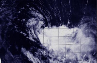
NASA's Aqua satellite captured this image of Gillian on March 25 at 06:30 UTC/2:30 a.m. EDT, now a tropical storm in the Southern Indian Ocean. Wind shear has pushed clouds and showers away from the center. Credit: NRL/NASA
When NASA's Aqua satellite flew over Gillian on March 25 at 06:30 UTC/2:30 a.m. EDT, the Moderate Resolution Imaging Spectroradiometer or MODIS instrument took a visible picture of the storm.
That image showed that wind shear has pushed clouds and showers away from the center as the storm weakened to a tropical storm.
In the MODIS image, the center of Gillian's circulation is surrounded by some cloudiness, while the bulk of clouds and showers has been pushed to the east-southeast from wind shear from the northwest.
On March 26 at 0900 UTC/5 a.m. EDT, Gillian's maximum sustained winds were near 60 knots. It was centered near 19.6 south latitude and 103.9 east longitude, about 594 nautical miles/683.6 miles/1,100 km west-northwest of Learmonth, Western Australia.
Gillian was moving to the south at 6 knots/6.9 mph/11.1 kph.
The Joint Typhoon Warning Center or JTWC expects Gillian to weaken quickly today as it turns to the southwest in the open waters of the Southern Indian Ocean.
The factors contributing to its rapid weakening include strong wind shear, subsidence or sinking air aloft, and movement into cooler sea surface temperatures.
JTWC forecasters expect Gillian to dissipate by March 26.
Media Contact
More Information:
http://www.nasa.govAll latest news from the category: Earth Sciences
Earth Sciences (also referred to as Geosciences), which deals with basic issues surrounding our planet, plays a vital role in the area of energy and raw materials supply.
Earth Sciences comprises subjects such as geology, geography, geological informatics, paleontology, mineralogy, petrography, crystallography, geophysics, geodesy, glaciology, cartography, photogrammetry, meteorology and seismology, early-warning systems, earthquake research and polar research.


Newest articles

A universal framework for spatial biology
SpatialData is a freely accessible tool to unify and integrate data from different omics technologies accounting for spatial information, which can provide holistic insights into health and disease. Biological processes…

How complex biological processes arise
A $20 million grant from the U.S. National Science Foundation (NSF) will support the establishment and operation of the National Synthesis Center for Emergence in the Molecular and Cellular Sciences (NCEMS) at…

Airborne single-photon lidar system achieves high-resolution 3D imaging
Compact, low-power system opens doors for photon-efficient drone and satellite-based environmental monitoring and mapping. Researchers have developed a compact and lightweight single-photon airborne lidar system that can acquire high-resolution 3D…

