NASA satellite sees strengthening in Tropical Cyclone Khanun
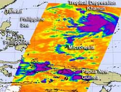
NASA's Aqua satellite captured a look at Khanun's cloud top temperatures on July 15, 2012, at 1635 UTC (12:35 p.m. EDT) when it was a tropical depression. Coldest cloud top temperatures (purple) were as cold as or colder than -63 Fahrenheit (-52 Celsius), indicating strong thunderstorms. That was a clue to forecasters that Khanun would become a tropical storm, which it did the next day. Credit: Credit: NASA JPL, Ed Olsen<br>
NASA's Aqua satellite flew over Khanun on July 15, 2012 at 1635 UTC (12:35 p.m. EDT) when it was a tropical depression. At that time the Atmospheric Infrared Sounder (AIRS) instrument onboard measured Khanun's cloud top temperatures.
The storm's coldest cloud top temperatures were as cold as or colder than -63 Fahrenheit (-52 Celsius), indicating strong thunderstorms with the potential for heavy rainfall. AIRS data also revealed that the area of strongest thunderstorms were becoming more organized, indicating that the tropical depression could strengthen into a tropical storm.
On July 16 at 1500 UTC (11 a.m. EDT), Khanun had become a tropical storm when maximum sustained winds reached 35 knots (40 mph/64.8 kmh). At that time Khanun was centered about 370 nautical miles (425.8 miles/685.2 km) east of Kadena Air Base, Okinawa, Japan, near 25.4 North and 133.6 East. Khanun is moving to the west-northwest near 17 knots (19.5 mph/31.4 kmh).
Infrared data on July 16 showed the Khanun continued to consolidate and had a larger area of stronger central convection (rising air that forms the thunderstorms that make up the tropical cyclone), so the system is getting more organized and stronger. Khanun is currently in an area where wind shear is weak allowing for more strengthening.
The Joint Typhoon Warning Center expects Khanun to begin curving to the northwest and passing north of Kadena Air Base on its way to a landfall in South Korea later this week. Khanun is following the periphery of a north-south oriented sub-tropical ridge (elongated area) of high pressure building up south of Honshu. Khanun is expected to make landfall as a tropical storm in South Korea in a few days.
Media Contact
More Information:
http://www.nasa.govAll latest news from the category: Earth Sciences
Earth Sciences (also referred to as Geosciences), which deals with basic issues surrounding our planet, plays a vital role in the area of energy and raw materials supply.
Earth Sciences comprises subjects such as geology, geography, geological informatics, paleontology, mineralogy, petrography, crystallography, geophysics, geodesy, glaciology, cartography, photogrammetry, meteorology and seismology, early-warning systems, earthquake research and polar research.


Newest articles

A universal framework for spatial biology
SpatialData is a freely accessible tool to unify and integrate data from different omics technologies accounting for spatial information, which can provide holistic insights into health and disease. Biological processes…

How complex biological processes arise
A $20 million grant from the U.S. National Science Foundation (NSF) will support the establishment and operation of the National Synthesis Center for Emergence in the Molecular and Cellular Sciences (NCEMS) at…

Airborne single-photon lidar system achieves high-resolution 3D imaging
Compact, low-power system opens doors for photon-efficient drone and satellite-based environmental monitoring and mapping. Researchers have developed a compact and lightweight single-photon airborne lidar system that can acquire high-resolution 3D…

