NASA Satellite Sees a Somewhat Lopsided Typhoon Halong
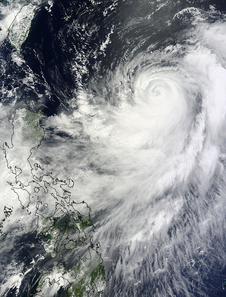
On Aug. 5 at 02:15 UTC, the MODIS instrument aboard NASA's Terra satellite captured this visible image of Typhoon Halong in the western Pacific Ocean. Image Credit: NASA Goddard MODIS Rapid Response Team
When NASA's Aqua satellite passed over Typhoon Halong on Aug. 4 at 12:47 a.m. EDT, the Atmospheric Infrared Sounder (AIRS) instrument aboard provided infrared data on the cloud top temperatures of Typhoon Halong.
AIRS data showed powerful thunderstorms with the highest, coldest cloud tops circled the center of the storm and were in two thick bands in the southern and eastern quadrants of the storm. Cloud top temperatures exceeded -63F/-52C indicating they were nearing the top of the troposphere.
NASA research has shown that cloud top temperatures that cold, from storms that high, have the potential to produce heavy rainfall.
The other thing that the infrared imagery showed was a degradation of strong convection and thunderstorm development in the northern half of the storm. The Joint Typhoon Warning Center noted that development is being inhibited because of subsidence, that is, the sinking of air (from above).
In order for thunderstorms to form, air needs to rise and condense into clouds. When air is sinking from overhead, it prevents cloud formation from happening.
On Aug. 5 at 02:15 UTC, the MODIS instrument aboard NASA's Terra satellite captured a visible image of Typhoon Halong in the western Pacific Ocean that showed the strongest bands of thunderstorms continued to be in the southern and eastern quadrants of the storm.
At 1500 UTC (11 a.m. EDT) Halong's center was located near 21.4 north latitude and 130.1 east longitude, about 351 nautical miles (403.9 miles/ 650.1 km) south-southeast of Kadena Air Base, Okinawa. Maximum sustained winds were near 85 knots (97.8 mph/157.4 kph).
Halong continues to generate extremely rough seas with maximum significant wave heights at 35 feet (10.6 meters).
JTWC forecasters expect Halong to continue moving north-northeast over the next day or two before taking a more northerly track toward mainland Japan.
Text credit: Rob Gutro
NASA's Goddard Space Flight Center
Media Contact
More Information:
http://www.nasa.gov/content/goddard/11w-northwestern-pacific-ocean/All latest news from the category: Earth Sciences
Earth Sciences (also referred to as Geosciences), which deals with basic issues surrounding our planet, plays a vital role in the area of energy and raw materials supply.
Earth Sciences comprises subjects such as geology, geography, geological informatics, paleontology, mineralogy, petrography, crystallography, geophysics, geodesy, glaciology, cartography, photogrammetry, meteorology and seismology, early-warning systems, earthquake research and polar research.


Newest articles

How evolution has optimised the magnetic sensor in birds
The magnetic sense of migratory birds is probably based on the protein cryptochrome 4, and a genetic study has now provided further support for this theory. A team of researchers…

Molecular Fingerprint Beyond the Nyquist Frequency
Ultrafast laser spectroscopy allows the ascertainment of dynamics over extremely short time scales, making it a very useful tool in many scientific and industrial applications. A major disadvantage is the…

High-energy-density aqueous battery based on halogen multi-electron transfer
Traditional non-aqueous lithium-ion batteries have a high energy density, but their safety is compromised due to the flammable organic electrolytes they utilize. Aqueous batteries use water as the solvent for…

