NASA Satellite catches a tropical cyclone forming near Darwin, Australia
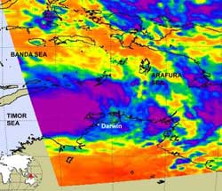
The AIRS instrument aboard NASA\'s Aqua satellite captured an infrared image of System 99S on Feb. 15 at 0441 UTC. The strongest convection (purple) was over the Timor Sea and represented in thunderstorm cloud-top temperatures as cold as or colder than -63 Fahrenheit (-52 Celsius). Credit: NASA JPL, Ed Olsen<br>
System 99S is a threat to Australia's Northern Territory because on Feb. 15 it was centered only 20 miles (32 km) south of Darwin, Australia, near 12.7 degrees South latitude and 130.7 degrees East longitude. The Joint Typhoon Warning Center gives System 99S a good chance for development in the next 24 hours, and NASA satellite imagery confirms the strong convection and thunderstorms developing in the system.
The Atmospheric Infrared Sounder (AIRS) instrument aboard NASA's Aqua satellite captured an infrared image of System 99S on Feb. 15 at 0441 UTC. The infrared image was created at NASA's Jet Propulsion Laboratory in Pasadena, Calif. and showed very strong convection over the Timor Sea (part of the Southern Indian Ocean basin), with the southernmost edge of precipitation near Darwin. That strong convection was represented in thunderstorm cloud-top temperatures as cold as or colder than -63 Fahrenheit (-52 Celsius). Cyclones or hurricanes are made up of hundreds of thunderstorms that circle a low pressure center.
Warnings are now in effect for the Northern Territories, Australia. A Cyclone Warning is in effect for coastal areas from Daly River Mouth to Point Stuart, including Darwin and the Tiwi Islands. In addition, a Cyclone Watch is in effect for coastal areas from Port Keats to Daly River Mouth and Point Stuart to Goulburn Island.
Winds in the area of Darwin are estimated near 25 to 30 knots 29 to 34 mph/36 to 55 kmh). System 99S is meandering northwestward at 1 knot (1 mph/2 kmh). Doppler weather radar at Darwin shows intense convection (thunderstorms) banding along the northern semicircle of the low level circulation center.
Forecasters expect System 99S to strengthen as its center drifts over the warm ocean surface. Currently, there is a good chance that System 99S will become a tropical depression or tropical storm.
Media Contact
More Information:
http://www.nasa.govAll latest news from the category: Earth Sciences
Earth Sciences (also referred to as Geosciences), which deals with basic issues surrounding our planet, plays a vital role in the area of energy and raw materials supply.
Earth Sciences comprises subjects such as geology, geography, geological informatics, paleontology, mineralogy, petrography, crystallography, geophysics, geodesy, glaciology, cartography, photogrammetry, meteorology and seismology, early-warning systems, earthquake research and polar research.


Newest articles

A universal framework for spatial biology
SpatialData is a freely accessible tool to unify and integrate data from different omics technologies accounting for spatial information, which can provide holistic insights into health and disease. Biological processes…

How complex biological processes arise
A $20 million grant from the U.S. National Science Foundation (NSF) will support the establishment and operation of the National Synthesis Center for Emergence in the Molecular and Cellular Sciences (NCEMS) at…

Airborne single-photon lidar system achieves high-resolution 3D imaging
Compact, low-power system opens doors for photon-efficient drone and satellite-based environmental monitoring and mapping. Researchers have developed a compact and lightweight single-photon airborne lidar system that can acquire high-resolution 3D…

