NASA satellite analyzes new Southern Pacific Ocean tropical cyclone
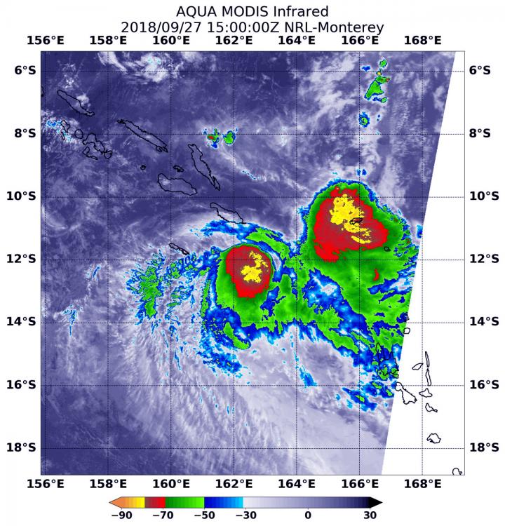
At 11 a.m. EDT (1500 UTC) on Sept. 27, the MODIS instrument aboard NASA's Aqua satellite looked at Tropical Storm Liua in infrared light. MODIS found two areas of coldest cloud top temperatures west and northeast of Liua's center were as cold as or colder than minus 80 degrees (yellow) Fahrenheit (minus 112 degrees Celsius). Surrounding them were storms with cloud tops as cold as or colder than minus 70 degrees (red) Fahrenheit (minus 56.6 degrees Celsius). Credit: NASA/NRL
At 11 a.m. EDT (1500 UTC) on Sept. 27, the MODIS or Moderate Resolution Imaging Spectroradiometer instrument aboard NASA's Aqua satellite looked at Tropical Storm Liua in infrared light. MODIS found two areas of coldest cloud top temperatures west and northeast of Liua's center were as cold as or colder than minus 80 degrees Fahrenheit (minus 112 degrees Celsius).
Those areas represented the strongest storms. Surrounding them were storms with cloud tops as cold as or colder than minus 70 degrees Fahrenheit (minus 56.6 degrees Celsius).
NASA research has found that cloud top temperatures as cold as or colder than the 70F/56.6C threshold have the capability to generate heavy rainfall.
At 11 a.m. EDT (1500 UTC), the center of Tropical Storm Liua was located near latitude 12.2 degrees south and longitude 162.5 degrees east.
That's about 471 miles northwest of Port Vila, Vanuatu. Liua was moving toward the south-southwest. Liua's maximum sustained winds were near 40 mph (35 knots/62 kph) with higher gusts.
The Joint Typhoon Warning Center noted that the forecast takes Liua west over cooler sea surface temperatures and where outside winds will weaken the storm. Liua is forecast to dissipate by Sept. 29.
Media Contact
More Information:
https://blogs.nasa.gov/hurricanes/tag/liua-2018/All latest news from the category: Earth Sciences
Earth Sciences (also referred to as Geosciences), which deals with basic issues surrounding our planet, plays a vital role in the area of energy and raw materials supply.
Earth Sciences comprises subjects such as geology, geography, geological informatics, paleontology, mineralogy, petrography, crystallography, geophysics, geodesy, glaciology, cartography, photogrammetry, meteorology and seismology, early-warning systems, earthquake research and polar research.


Newest articles

A universal framework for spatial biology
SpatialData is a freely accessible tool to unify and integrate data from different omics technologies accounting for spatial information, which can provide holistic insights into health and disease. Biological processes…

How complex biological processes arise
A $20 million grant from the U.S. National Science Foundation (NSF) will support the establishment and operation of the National Synthesis Center for Emergence in the Molecular and Cellular Sciences (NCEMS) at…

Airborne single-photon lidar system achieves high-resolution 3D imaging
Compact, low-power system opens doors for photon-efficient drone and satellite-based environmental monitoring and mapping. Researchers have developed a compact and lightweight single-photon airborne lidar system that can acquire high-resolution 3D…

