NASA's infrared look at strengthening Typhoon Chan-Hom
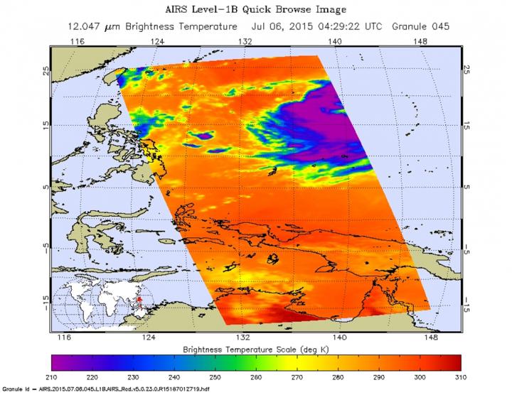
The AIRS instrument aboard NASA's Aqua satellite gathered infrared temperature data on Chan-Hom when it was a Tropical Storm on July 6 at 04:29 UTC (12:29 a.m. EDT). Purple areas indicate the coldest cloud tops and strongest thunderstorms within. Credit: NASA JPL, Ed Olsen
The Atmospheric Infrared Sounder or AIRS instrument that flies aboard NASA's Aqua satellite gathered infrared temperature data on Chan-Hom when it was a Tropical Storm on July 6 at 04:29 UTC (12:29 a.m. EDT).
The coldest thunderstorm cloud tops measured were near -63 Fahrenheit or -52 Celsius. Cloud top temperatures that cold are high into the troposphere and capable of generating heavy rain.
The Joint Typhoon Warning Center (JTWC) looked at animated infrared imagery that showed a slight improvement in organization with a marked increase in central convection (rising air that forms the thunderstorms that make up a tropical cyclone). Other satellite imagery showed that there were tightly-curved bands of thunderstorms wrapping into a defined center.
Between 0900 UTC and 1500 UTC today, July 6, Chan-Hom's maximum sustained winds increased from 60 knots (69 mph/111 kph) to 65 knots (75 mph/120 kph) bringing it to typhoon strength.
It was centered near 18.1 North latitude and 138.9 East longitude, about 825 nautical miles southeast of Kadena Air Force Base, Guam. Chan-Hom has tracked west-northwestward at 14 knots (16 mph/26 kph).
Chan-Hom is intensifying as it moves northwest through the Northwestern Pacific Ocean. The JTWC forecasts the storm to continue to strengthen over the next three days and expected to peak as a Category 4 typhoon on the Saffir-Simpson Wind Scale, with maximum sustained winds nearing 130 knots (149.6 mph/240.8 kph). The storm is forecast to pass between Ishigakjima and Kadena islands on July 9 before making landfall in eastern China as a typhoon.
Media Contact
All latest news from the category: Earth Sciences
Earth Sciences (also referred to as Geosciences), which deals with basic issues surrounding our planet, plays a vital role in the area of energy and raw materials supply.
Earth Sciences comprises subjects such as geology, geography, geological informatics, paleontology, mineralogy, petrography, crystallography, geophysics, geodesy, glaciology, cartography, photogrammetry, meteorology and seismology, early-warning systems, earthquake research and polar research.


Newest articles

A universal framework for spatial biology
SpatialData is a freely accessible tool to unify and integrate data from different omics technologies accounting for spatial information, which can provide holistic insights into health and disease. Biological processes…

How complex biological processes arise
A $20 million grant from the U.S. National Science Foundation (NSF) will support the establishment and operation of the National Synthesis Center for Emergence in the Molecular and Cellular Sciences (NCEMS) at…

Airborne single-photon lidar system achieves high-resolution 3D imaging
Compact, low-power system opens doors for photon-efficient drone and satellite-based environmental monitoring and mapping. Researchers have developed a compact and lightweight single-photon airborne lidar system that can acquire high-resolution 3D…

