NASA's GPM satellite examines tornadic thunderstorms
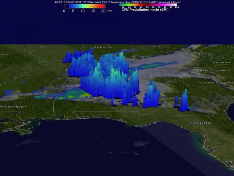
The GPM core observatory satellite flew over the southern U.S. on March 31, 2016, at 10:41 p.m. EDT (April 1, 2016, at 2:41 a.m. UTC) where a tornado was reported near Hartselle, Alabama, less than an hour before the satellite passed over. Rain was falling at more than 91 mm (3.6 inches) per hour east of Chattanooga, Tennessee. Storm tops in Alabama reached above 12 km (7.4 miles). This image represents observed rainfall rates per hour. Credits: NASA/JAXA, Hal Pierce
Over the last few days tornado spawning thunderstorms have occurred in the states of Texas, Oklahoma, Arkansas, Louisiana, Indiana, Mississippi, Alabama and Georgia. Large hail, damaging winds and flash flooding associated with a frontal system moving across the United States have compounded the damage from these storms. Hail the size of a half-dollar was reported near Jackson, Louisiana, on Thursday evening, March 31.
The GPM core observatory satellite flew over this stormy area on March 31, 2016, at 10:41 p.m. EDT (April 1, 2016, 2:41 a.m. UTC). Tornadoes were reported in Mississippi, Alabama and Georgia during the evening. A tornado was reported near Hartselle, Alabama, less than an hour before the satellite passed over.
A rainfall analysis was derived from data collected by GPM's Microwave Imager (GMI) and Dual-Frequency Precipitation Radar (DPR) instruments. The GPM radar (DPR) measured rain falling at the extreme rate of more than 91 mm (3.6 inches) per hour in a powerful storm east of Chattanooga, Tennessee.
At NASA's Goddard Space Flight Center in Greenbelt, Maryland, data from the GPM satellite's radar (GPM Ku band) were used to reveal the three dimensional structure of precipitation in storms beneath the satellite. GPM's radar found that storm tops in Alabama were reaching heights above 12 km (7.4) miles. The locations of intense storms were also revealed by this 3-D slice which shows radar echoes greater than 25 dBZ (decibels Z).
The National Weather Service Weather Prediction Center in College Park, Maryland, issued their Short Range Forecast Discussion at 1:28 a.m. EDT on April 1. The discussion called for heavy rain and strong thunderstorms in the southeastern U.S. states over the course of the day.
The NWS discussion said: A cold front crossing the East Coast tonight is expected to bring numerous showers and storms from the Northeast to Florida. Some of these thunderstorms may be severe across portions of the southeastern U.S. through early Saturday, April 2. There is also the possibility of some flash flooding in this same general area where one to three inches of rainfall will be possible, with locally higher amounts. For more information on U.S. forecasts visit: http://www.
###
For more information about GPM, visit: http://www.
Media Contact
All latest news from the category: Earth Sciences
Earth Sciences (also referred to as Geosciences), which deals with basic issues surrounding our planet, plays a vital role in the area of energy and raw materials supply.
Earth Sciences comprises subjects such as geology, geography, geological informatics, paleontology, mineralogy, petrography, crystallography, geophysics, geodesy, glaciology, cartography, photogrammetry, meteorology and seismology, early-warning systems, earthquake research and polar research.


Newest articles

A universal framework for spatial biology
SpatialData is a freely accessible tool to unify and integrate data from different omics technologies accounting for spatial information, which can provide holistic insights into health and disease. Biological processes…

How complex biological processes arise
A $20 million grant from the U.S. National Science Foundation (NSF) will support the establishment and operation of the National Synthesis Center for Emergence in the Molecular and Cellular Sciences (NCEMS) at…

Airborne single-photon lidar system achieves high-resolution 3D imaging
Compact, low-power system opens doors for photon-efficient drone and satellite-based environmental monitoring and mapping. Researchers have developed a compact and lightweight single-photon airborne lidar system that can acquire high-resolution 3D…

