NASA-NOAA's Suomi NPP Satellite Sees Tropical Cyclone 05B Headed to India
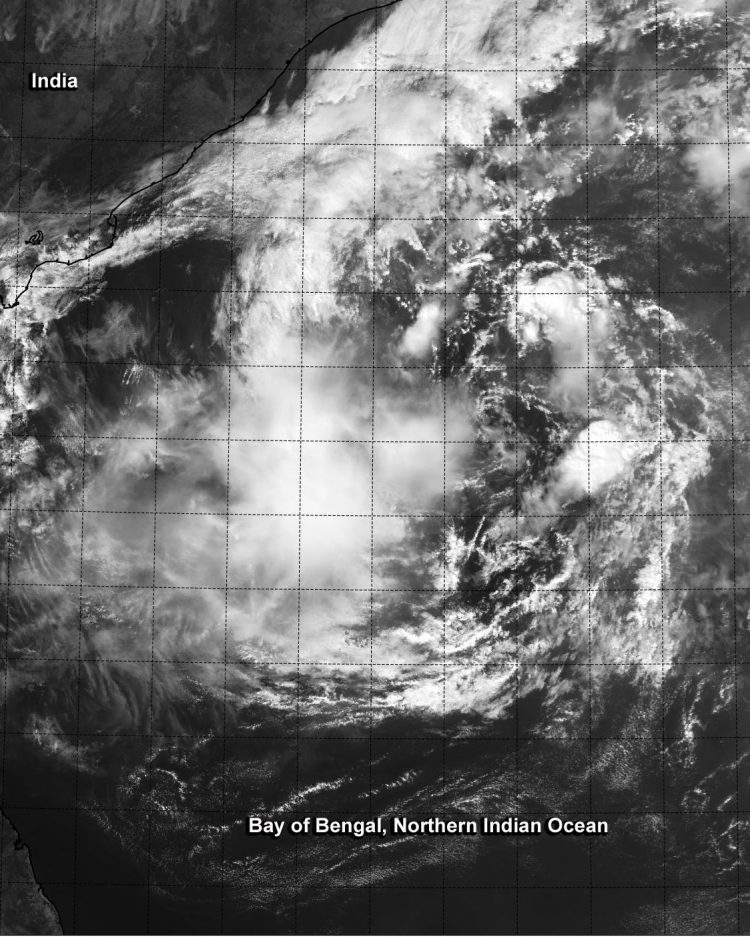
NASA-NOAA's Suomi NPP satellite flew over Tropical Cyclone 05B on 3:09 a.m. EST and the VIIRS instrument saw fragmented bands of thunderstorms around the storm. Image Credit: NASA/NOAA
When Suomi NPP flew over Tropical Cyclone 05B (TC05B) on Nov. 7 at 08:09 UTC (3:09 a.m. EST), the Visible Infrared Imaging Radiometer Suite or VIIRS instrument aboard captured a visible image of the storm. The VIIRS image showed a band of thunderstorms wrapping into the center from the northern quadrant, and fragmented bands of thunderstorms around the rest of the storm.
VIIRS is a scanning radiometer that collects visible and infrared imagery and “radiometric” measurements. Basically it means that VIIRS data is used to measure cloud and aerosol properties, ocean color, sea and land surface temperature, ice motion and temperature, fires, and Earth's albedo (reflected light).
At 1400 UTC (9 a.m. EST) Tropical Cyclone 05B's (TC05B) maximum sustained winds were near 35 knots (40.2 mph/64.8 kph). It was located near 14.3 north latitude and 87.4 east longitude, about 333 nautical miles (383.2 miles/616.7 km) southeast of Visakhapatnam, India. TC05B was moving to the north at 2 knots (2.3 mph/3.7 kph), and is expected to turn to the west.
The India Meteorological Department's Regional Specialised Meteorological Centre (RSMC) forecast noted that light to moderate rainfall would occur at a few places on Nov. 8 and on Nov. 9 would spread over a larger area over Andhra Pradesh and adjoining north coastal Tamil Nadu as TC05B nears.
RSMC calls for sustained winds between 30 and 40 kph with higher gusts along and off the coasts of Andhra Pradesh and north Tamilnadu. Sea conditions are expected to be rough along those coasts both days and fishermen were advised not to venture out to sea. For updated forecasts from RSMC, visit: http://www.rsmcnewdelhi.imd.gov.in .
Tropical Cyclone 05B is forecast to continue moving west and strengthen a little before making landfall between Visakhapatnam and Chennai in eastern India on November 9.
Rob Gutro
NASA's Goddard Space Flight Center
Media Contact
More Information:
http://www.nasa.gov/content/goddard/05b-northern-indian-ocean/All latest news from the category: Earth Sciences
Earth Sciences (also referred to as Geosciences), which deals with basic issues surrounding our planet, plays a vital role in the area of energy and raw materials supply.
Earth Sciences comprises subjects such as geology, geography, geological informatics, paleontology, mineralogy, petrography, crystallography, geophysics, geodesy, glaciology, cartography, photogrammetry, meteorology and seismology, early-warning systems, earthquake research and polar research.


Newest articles

A universal framework for spatial biology
SpatialData is a freely accessible tool to unify and integrate data from different omics technologies accounting for spatial information, which can provide holistic insights into health and disease. Biological processes…

How complex biological processes arise
A $20 million grant from the U.S. National Science Foundation (NSF) will support the establishment and operation of the National Synthesis Center for Emergence in the Molecular and Cellular Sciences (NCEMS) at…

Airborne single-photon lidar system achieves high-resolution 3D imaging
Compact, low-power system opens doors for photon-efficient drone and satellite-based environmental monitoring and mapping. Researchers have developed a compact and lightweight single-photon airborne lidar system that can acquire high-resolution 3D…

